You are here: Home > Network List > LD - Lamont-Doherty Cooperative Seismographic Network Stations List
> Station WUPA West Chester University of Pennsylvania > Earthquake Result Viewer
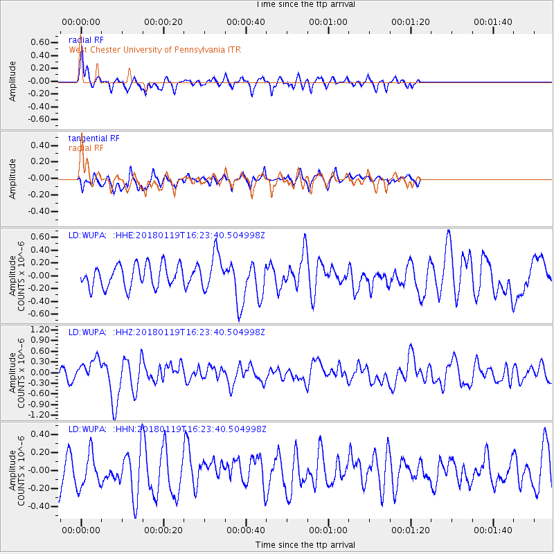
WUPA West Chester University of Pennsylvania - Earthquake Result Viewer
*The percent match for this event was below the threshold and hence no stack was calculated.
| Earthquake location: |
Gulf Of California |
| Earthquake latitude/longitude: |
26.7/-111.1 |
| Earthquake time(UTC): |
2018/01/19 (019) 16:17:42 GMT |
| Earthquake Depth: |
10 km |
| Earthquake Magnitude: |
6.3 Mww |
| Earthquake Catalog/Contributor: |
NEIC PDE/us |
|
| Network: |
LD Lamont-Doherty Cooperative Seismographic Network |
| Station: |
WUPA West Chester University of Pennsylvania |
| Lat/Lon: |
39.93 N/75.61 W |
| Elevation: |
86 m |
|
| Distance: |
32.3 deg |
| Az: |
56.774 deg |
| Baz: |
256.754 deg |
| Ray Param: |
$rayparam |
*The percent match for this event was below the threshold and hence was not used in the summary stack. |
|
| Radial Match: |
72.83482 % |
| Radial Bump: |
334 |
| Transverse Match: |
41.910564 % |
| Transverse Bump: |
400 |
| SOD ConfigId: |
13570011 |
| Insert Time: |
2019-04-29 14:37:22.958 +0000 |
| GWidth: |
2.5 |
| Max Bumps: |
400 |
| Tol: |
0.001 |
|
Signal To Noise
| Channel | StoN | STA | LTA |
| LD:WUPA: :HHZ:20180119T16:23:40.504998Z | 2.170767 | 3.263096E-7 | 1.5031993E-7 |
| LD:WUPA: :HHN:20180119T16:23:40.504998Z | 0.9663314 | 1.9451758E-7 | 2.0129488E-7 |
| LD:WUPA: :HHE:20180119T16:23:40.504998Z | 1.6459275 | 2.833664E-7 | 1.7216213E-7 |
| Arrivals |
| Ps | |
| PpPs | |
| PsPs/PpSs | |


