You are here: Home > Network List > TA - USArray Transportable Network (new EarthScope stations) Stations List
> Station R24A Sanders Place, Florence, CO, USA > Earthquake Result Viewer
R24A Sanders Place, Florence, CO, USA - Earthquake Result Viewer

| Earthquake location: |
Northern Mid-Atlantic Ridge |
| Earthquake latitude/longitude: |
23.9/-46.1 |
| Earthquake time(UTC): |
2009/06/06 (157) 20:33:28 GMT |
| Earthquake Depth: |
14 km |
| Earthquake Magnitude: |
6.0 MB, 5.7 MS, 6.0 MW, 6.0 MW |
| Earthquake Catalog/Contributor: |
WHDF/NEIC |
|
| Network: |
TA USArray Transportable Network (new EarthScope stations) |
| Station: |
R24A Sanders Place, Florence, CO, USA |
| Lat/Lon: |
38.23 N/105.11 W |
| Elevation: |
1978 m |
|
| Distance: |
51.7 deg |
| Az: |
300.714 deg |
| Baz: |
88.084 deg |
| Ray Param: |
0.067205936 |
| Estimated Moho Depth: |
52.75 km |
| Estimated Crust Vp/Vs: |
1.64 |
| Assumed Crust Vp: |
6.159 km/s |
| Estimated Crust Vs: |
3.761 km/s |
| Estimated Crust Poisson's Ratio: |
0.20 |
|
| Radial Match: |
83.402664 % |
| Radial Bump: |
400 |
| Transverse Match: |
59.001606 % |
| Transverse Bump: |
400 |
| SOD ConfigId: |
2648 |
| Insert Time: |
2010-03-06 08:05:50.616 +0000 |
| GWidth: |
2.5 |
| Max Bumps: |
400 |
| Tol: |
0.001 |
|
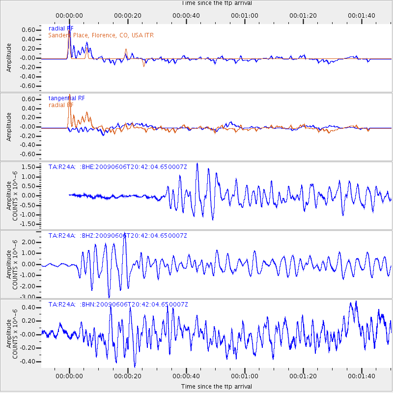
Signal To Noise
| Channel | StoN | STA | LTA |
| TA:R24A: :BHZ:20090606T20:42:04.650007Z | 7.4916325 | 5.1040286E-7 | 6.812973E-8 |
| TA:R24A: :BHN:20090606T20:42:04.650007Z | 1.0959401 | 6.4256824E-8 | 5.863169E-8 |
| TA:R24A: :BHE:20090606T20:42:04.650007Z | 4.5968285 | 2.5480705E-7 | 5.543106E-8 |
| Arrivals |
| Ps | 5.8 SECOND |
| PpPs | 21 SECOND |
| PsPs/PpSs | 27 SECOND |


