You are here: Home > Network List > TA - USArray Transportable Network (new EarthScope stations) Stations List
> Station A36M Sachs Harbour, NT, CAN > Earthquake Result Viewer
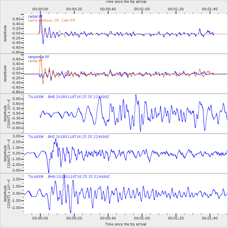
A36M Sachs Harbour, NT, CAN - Earthquake Result Viewer
*The percent match for this event was below the threshold and hence no stack was calculated.
| Earthquake location: |
Gulf Of California |
| Earthquake latitude/longitude: |
26.7/-111.1 |
| Earthquake time(UTC): |
2018/01/19 (019) 16:17:42 GMT |
| Earthquake Depth: |
10 km |
| Earthquake Magnitude: |
6.3 Mww |
| Earthquake Catalog/Contributor: |
NEIC PDE/us |
|
| Network: |
TA USArray Transportable Network (new EarthScope stations) |
| Station: |
A36M Sachs Harbour, NT, CAN |
| Lat/Lon: |
71.99 N/125.25 W |
| Elevation: |
32 m |
|
| Distance: |
46.0 deg |
| Az: |
353.937 deg |
| Baz: |
162.318 deg |
| Ray Param: |
$rayparam |
*The percent match for this event was below the threshold and hence was not used in the summary stack. |
|
| Radial Match: |
75.195946 % |
| Radial Bump: |
358 |
| Transverse Match: |
71.715576 % |
| Transverse Bump: |
400 |
| SOD ConfigId: |
13570011 |
| Insert Time: |
2019-04-29 14:38:34.267 +0000 |
| GWidth: |
2.5 |
| Max Bumps: |
400 |
| Tol: |
0.001 |
|
Signal To Noise
| Channel | StoN | STA | LTA |
| TA:A36M: :BHZ:20180119T16:25:35.224999Z | 3.3585985 | 9.06811E-7 | 2.6999686E-7 |
| TA:A36M: :BHN:20180119T16:25:35.224999Z | 1.604432 | 4.6182697E-7 | 2.8784453E-7 |
| TA:A36M: :BHE:20180119T16:25:35.224999Z | 3.7059588 | 4.7543864E-7 | 1.2829032E-7 |
| Arrivals |
| Ps | |
| PpPs | |
| PsPs/PpSs | |


