You are here: Home > Network List > TA - USArray Transportable Network (new EarthScope stations) Stations List
> Station A22K Sinclair Lake, AK, USA > Earthquake Result Viewer
A22K Sinclair Lake, AK, USA - Earthquake Result Viewer
| Earthquake location: |
Gulf Of California |
| Earthquake latitude/longitude: |
26.7/-111.1 |
| Earthquake time(UTC): |
2018/01/19 (019) 16:17:42 GMT |
| Earthquake Depth: |
10 km |
| Earthquake Magnitude: |
6.3 Mww |
| Earthquake Catalog/Contributor: |
NEIC PDE/us |
|
| Network: |
TA USArray Transportable Network (new EarthScope stations) |
| Station: |
A22K Sinclair Lake, AK, USA |
| Lat/Lon: |
71.00 N/154.97 W |
| Elevation: |
6.0 m |
|
| Distance: |
50.7 deg |
| Az: |
342.95 deg |
| Baz: |
126.764 deg |
| Ray Param: |
0.067871526 |
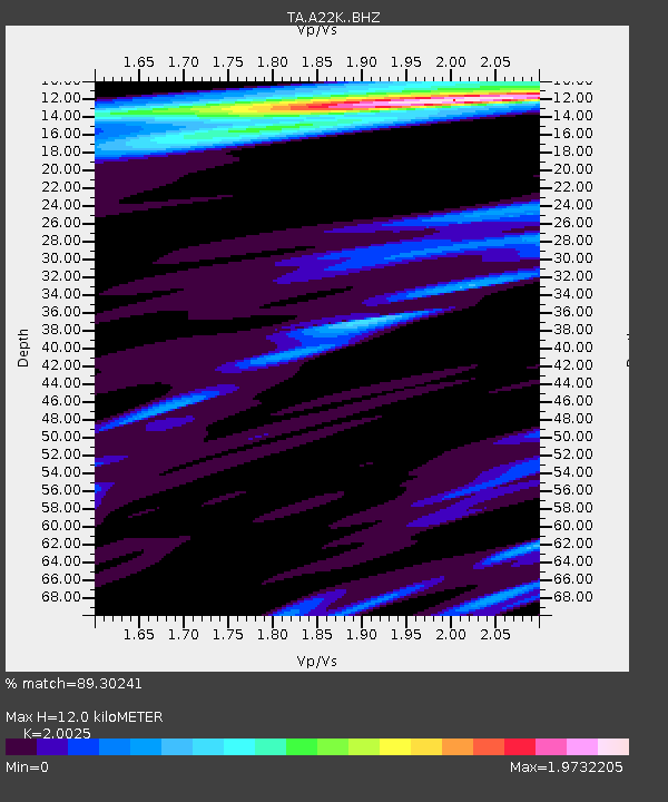
| Estimated Moho Depth: |
12.0 km |
| Estimated Crust Vp/Vs: |
2.00 |
| Assumed Crust Vp: |
5.782 km/s |
| Estimated Crust Vs: |
2.888 km/s |
| Estimated Crust Poisson's Ratio: |
0.33 |
|
| Radial Match: |
89.30241 % |
| Radial Bump: |
341 |
| Transverse Match: |
64.95287 % |
| Transverse Bump: |
400 |
| SOD ConfigId: |
13570011 |
| Insert Time: |
2019-04-29 14:38:34.292 +0000 |
| GWidth: |
2.5 |
| Max Bumps: |
400 |
| Tol: |
0.001 |
|

Signal To Noise
| Channel | StoN | STA | LTA |
| TA:A22K: :BHZ:20180119T16:26:11.349999Z | 2.6588893 | 4.670577E-7 | 1.7565895E-7 |
| TA:A22K: :BHN:20180119T16:26:11.349999Z | 1.676458 | 3.471814E-7 | 2.0709224E-7 |
| TA:A22K: :BHE:20180119T16:26:11.349999Z | 0.7491717 | 1.5637066E-7 | 2.0872474E-7 |
| Arrivals |
| Ps | 2.2 SECOND |
| PpPs | 6.0 SECOND |
| PsPs/PpSs | 8.2 SECOND |


