You are here: Home > Network List > TA - USArray Transportable Network (new EarthScope stations) Stations List
> Station F31M Tsiigehtchic, NWT, CAN > Earthquake Result Viewer
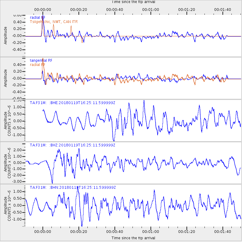
F31M Tsiigehtchic, NWT, CAN - Earthquake Result Viewer
*The percent match for this event was below the threshold and hence no stack was calculated.
| Earthquake location: |
Gulf Of California |
| Earthquake latitude/longitude: |
26.7/-111.1 |
| Earthquake time(UTC): |
2018/01/19 (019) 16:17:42 GMT |
| Earthquake Depth: |
10 km |
| Earthquake Magnitude: |
6.3 Mww |
| Earthquake Catalog/Contributor: |
NEIC PDE/us |
|
| Network: |
TA USArray Transportable Network (new EarthScope stations) |
| Station: |
F31M Tsiigehtchic, NWT, CAN |
| Lat/Lon: |
67.44 N/133.74 W |
| Elevation: |
56 m |
|
| Distance: |
43.1 deg |
| Az: |
347.438 deg |
| Baz: |
149.712 deg |
| Ray Param: |
$rayparam |
*The percent match for this event was below the threshold and hence was not used in the summary stack. |
|
| Radial Match: |
69.70295 % |
| Radial Bump: |
400 |
| Transverse Match: |
65.10998 % |
| Transverse Bump: |
400 |
| SOD ConfigId: |
13570011 |
| Insert Time: |
2019-04-29 14:38:46.760 +0000 |
| GWidth: |
2.5 |
| Max Bumps: |
400 |
| Tol: |
0.001 |
|
Signal To Noise
| Channel | StoN | STA | LTA |
| TA:F31M: :BHZ:20180119T16:25:11.599999Z | 2.6184258 | 7.441608E-7 | 2.8420158E-7 |
| TA:F31M: :BHN:20180119T16:25:11.599999Z | 0.7133491 | 2.2924246E-7 | 3.2136083E-7 |
| TA:F31M: :BHE:20180119T16:25:11.599999Z | 0.66172814 | 2.3516561E-7 | 3.5538102E-7 |
| Arrivals |
| Ps | |
| PpPs | |
| PsPs/PpSs | |


