You are here: Home > Network List > TA - USArray Transportable Network (new EarthScope stations) Stations List
> Station J18K Innoko River, AK, USA > Earthquake Result Viewer
J18K Innoko River, AK, USA - Earthquake Result Viewer
| Earthquake location: |
Gulf Of California |
| Earthquake latitude/longitude: |
26.7/-111.1 |
| Earthquake time(UTC): |
2018/01/19 (019) 16:17:42 GMT |
| Earthquake Depth: |
10 km |
| Earthquake Magnitude: |
6.3 Mww |
| Earthquake Catalog/Contributor: |
NEIC PDE/us |
|
| Network: |
TA USArray Transportable Network (new EarthScope stations) |
| Station: |
J18K Innoko River, AK, USA |
| Lat/Lon: |
63.47 N/156.72 W |
| Elevation: |
506 m |
|
| Distance: |
47.1 deg |
| Az: |
334.036 deg |
| Baz: |
119.29 deg |
| Ray Param: |
0.070184976 |
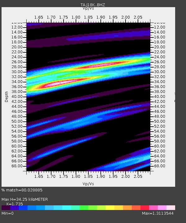
| Estimated Moho Depth: |
34.25 km |
| Estimated Crust Vp/Vs: |
1.74 |
| Assumed Crust Vp: |
6.182 km/s |
| Estimated Crust Vs: |
3.563 km/s |
| Estimated Crust Poisson's Ratio: |
0.25 |
|
| Radial Match: |
80.028885 % |
| Radial Bump: |
349 |
| Transverse Match: |
61.687935 % |
| Transverse Bump: |
356 |
| SOD ConfigId: |
13570011 |
| Insert Time: |
2019-04-29 14:38:55.515 +0000 |
| GWidth: |
2.5 |
| Max Bumps: |
400 |
| Tol: |
0.001 |
|

Signal To Noise
| Channel | StoN | STA | LTA |
| TA:J18K: :BHZ:20180119T16:25:44.024987Z | 2.8186736 | 3.9590512E-7 | 1.4045796E-7 |
| TA:J18K: :BHN:20180119T16:25:44.024987Z | 0.85414875 | 1.2970423E-7 | 1.5185205E-7 |
| TA:J18K: :BHE:20180119T16:25:44.024987Z | 1.0106363 | 2.570451E-7 | 2.5433982E-7 |
| Arrivals |
| Ps | 4.3 SECOND |
| PpPs | 14 SECOND |
| PsPs/PpSs | 19 SECOND |


