You are here: Home > Network List > US - United States National Seismic Network Stations List
> Station CBKS Cedar Bluff, Kansas, USA > Earthquake Result Viewer
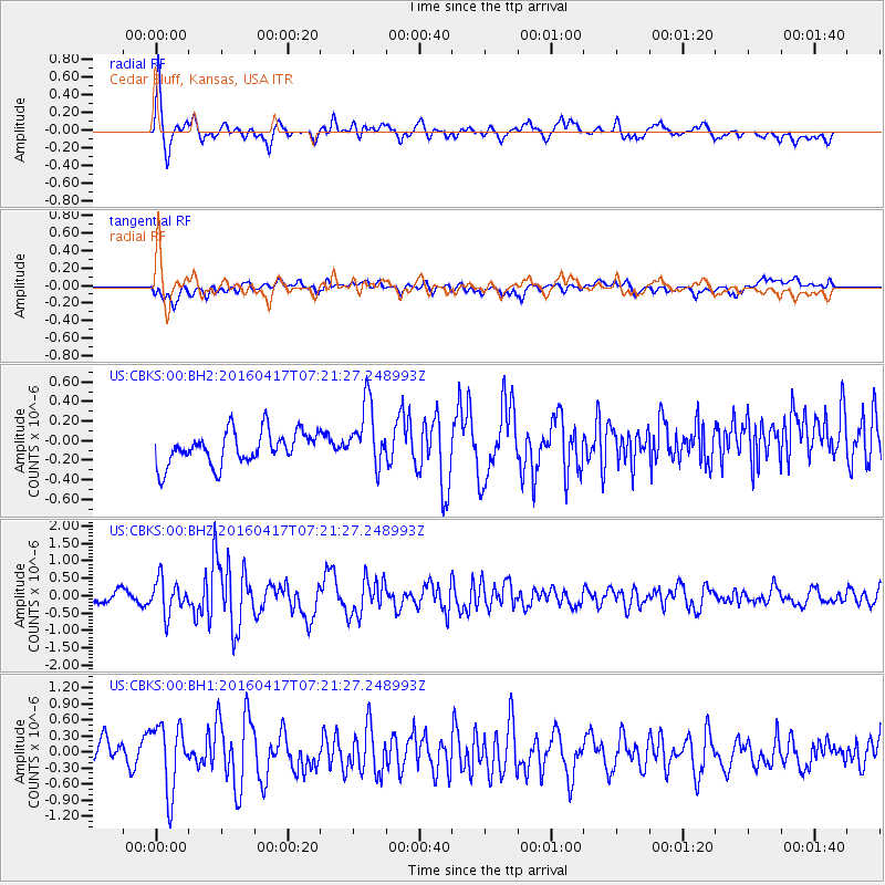
CBKS Cedar Bluff, Kansas, USA - Earthquake Result Viewer
*The percent match for this event was below the threshold and hence no stack was calculated.
| Earthquake location: |
Near Coast Of Ecuador |
| Earthquake latitude/longitude: |
-0.4/-80.3 |
| Earthquake time(UTC): |
2016/04/17 (108) 07:13:59 GMT |
| Earthquake Depth: |
10 km |
| Earthquake Magnitude: |
5.6 MB |
| Earthquake Catalog/Contributor: |
NEIC PDE/NEIC ALERT |
|
| Network: |
US United States National Seismic Network |
| Station: |
CBKS Cedar Bluff, Kansas, USA |
| Lat/Lon: |
38.81 N/99.74 W |
| Elevation: |
677 m |
|
| Distance: |
43.0 deg |
| Az: |
337.537 deg |
| Baz: |
150.721 deg |
| Ray Param: |
$rayparam |
*The percent match for this event was below the threshold and hence was not used in the summary stack. |
|
| Radial Match: |
78.37437 % |
| Radial Bump: |
400 |
| Transverse Match: |
61.26555 % |
| Transverse Bump: |
400 |
| SOD ConfigId: |
1475611 |
| Insert Time: |
2016-05-01 07:23:52.317 +0000 |
| GWidth: |
2.5 |
| Max Bumps: |
400 |
| Tol: |
0.001 |
|
Signal To Noise
| Channel | StoN | STA | LTA |
| US:CBKS:00:BHZ:20160417T07:21:27.248993Z | 3.0771532 | 4.8550186E-7 | 1.577763E-7 |
| US:CBKS:00:BH1:20160417T07:21:27.248993Z | 3.3316169 | 6.2652873E-7 | 1.8805545E-7 |
| US:CBKS:00:BH2:20160417T07:21:27.248993Z | 1.940493 | 3.2435733E-7 | 1.6715204E-7 |
| Arrivals |
| Ps | |
| PpPs | |
| PsPs/PpSs | |


