You are here: Home > Network List > US - United States National Seismic Network Stations List
> Station DGMT Dagmar, Montana, USA > Earthquake Result Viewer
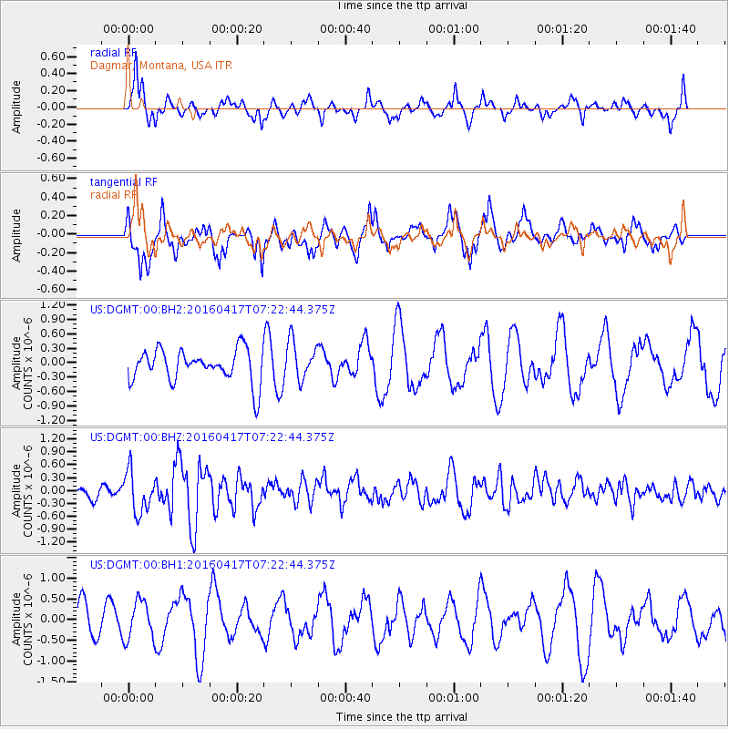
DGMT Dagmar, Montana, USA - Earthquake Result Viewer
*The percent match for this event was below the threshold and hence no stack was calculated.
| Earthquake location: |
Near Coast Of Ecuador |
| Earthquake latitude/longitude: |
-0.4/-80.3 |
| Earthquake time(UTC): |
2016/04/17 (108) 07:13:59 GMT |
| Earthquake Depth: |
10 km |
| Earthquake Magnitude: |
5.6 MB |
| Earthquake Catalog/Contributor: |
NEIC PDE/NEIC ALERT |
|
| Network: |
US United States National Seismic Network |
| Station: |
DGMT Dagmar, Montana, USA |
| Lat/Lon: |
48.47 N/104.20 W |
| Elevation: |
0.0 m |
|
| Distance: |
52.9 deg |
| Az: |
340.231 deg |
| Baz: |
149.454 deg |
| Ray Param: |
$rayparam |
*The percent match for this event was below the threshold and hence was not used in the summary stack. |
|
| Radial Match: |
59.257774 % |
| Radial Bump: |
361 |
| Transverse Match: |
67.53098 % |
| Transverse Bump: |
400 |
| SOD ConfigId: |
1475611 |
| Insert Time: |
2016-05-01 07:24:11.810 +0000 |
| GWidth: |
2.5 |
| Max Bumps: |
400 |
| Tol: |
0.001 |
|
Signal To Noise
| Channel | StoN | STA | LTA |
| US:DGMT:00:BHZ:20160417T07:22:44.375Z | 2.4627662 | 4.8620495E-7 | 1.974223E-7 |
| US:DGMT:00:BH1:20160417T07:22:44.375Z | 1.400549 | 4.701101E-7 | 3.356613E-7 |
| US:DGMT:00:BH2:20160417T07:22:44.375Z | 1.2066927 | 4.0668988E-7 | 3.3702852E-7 |
| Arrivals |
| Ps | |
| PpPs | |
| PsPs/PpSs | |


