You are here: Home > Network List > N4 - Central and EAstern US Network Stations List
> Station O49A Covington, OH, USA > Earthquake Result Viewer
O49A Covington, OH, USA - Earthquake Result Viewer
| Earthquake location: |
Northern Chile |
| Earthquake latitude/longitude: |
-18.9/-69.6 |
| Earthquake time(UTC): |
2018/01/21 (021) 01:06:42 GMT |
| Earthquake Depth: |
111 km |
| Earthquake Magnitude: |
6.3 Mww |
| Earthquake Catalog/Contributor: |
NEIC PDE/us |
|
| Network: |
N4 Central and EAstern US Network |
| Station: |
O49A Covington, OH, USA |
| Lat/Lon: |
40.19 N/84.34 W |
| Elevation: |
292 m |
|
| Distance: |
60.4 deg |
| Az: |
347.058 deg |
| Baz: |
163.93 deg |
| Ray Param: |
0.06126613 |
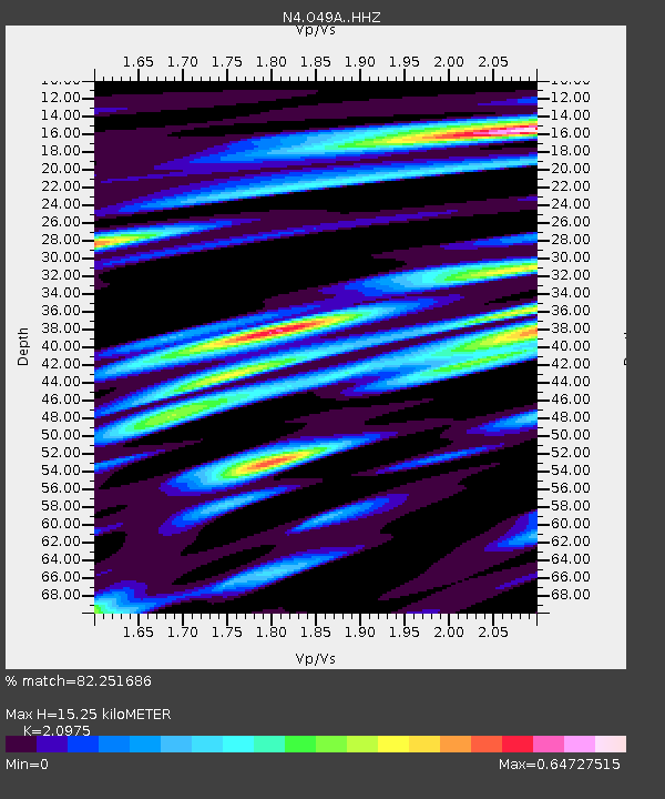
| Estimated Moho Depth: |
15.25 km |
| Estimated Crust Vp/Vs: |
2.10 |
| Assumed Crust Vp: |
6.498 km/s |
| Estimated Crust Vs: |
3.098 km/s |
| Estimated Crust Poisson's Ratio: |
0.35 |
|
| Radial Match: |
82.251686 % |
| Radial Bump: |
374 |
| Transverse Match: |
65.24108 % |
| Transverse Bump: |
400 |
| SOD ConfigId: |
13570011 |
| Insert Time: |
2019-04-29 14:45:26.903 +0000 |
| GWidth: |
2.5 |
| Max Bumps: |
400 |
| Tol: |
0.001 |
|

Signal To Noise
| Channel | StoN | STA | LTA |
| N4:O49A: :HHZ:20180121T01:16:08.96001Z | 9.606552 | 2.5445502E-6 | 2.6487655E-7 |
| N4:O49A: :HHN:20180121T01:16:08.96001Z | 5.7628508 | 1.0229066E-6 | 1.7750011E-7 |
| N4:O49A: :HHE:20180121T01:16:08.96001Z | 1.4712383 | 2.2111178E-7 | 1.5028958E-7 |
| Arrivals |
| Ps | 2.7 SECOND |
| PpPs | 7.0 SECOND |
| PsPs/PpSs | 9.7 SECOND |


