You are here: Home > Network List > N4 - Central and EAstern US Network Stations List
> Station U59A Littleton, NC, USA > Earthquake Result Viewer
U59A Littleton, NC, USA - Earthquake Result Viewer
| Earthquake location: |
Northern Chile |
| Earthquake latitude/longitude: |
-18.9/-69.6 |
| Earthquake time(UTC): |
2018/01/21 (021) 01:06:42 GMT |
| Earthquake Depth: |
111 km |
| Earthquake Magnitude: |
6.3 Mww |
| Earthquake Catalog/Contributor: |
NEIC PDE/us |
|
| Network: |
N4 Central and EAstern US Network |
| Station: |
U59A Littleton, NC, USA |
| Lat/Lon: |
36.35 N/77.79 W |
| Elevation: |
99 m |
|
| Distance: |
55.5 deg |
| Az: |
351.99 deg |
| Baz: |
170.594 deg |
| Ray Param: |
0.06442376 |
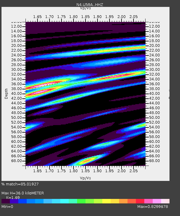
| Estimated Moho Depth: |
36.0 km |
| Estimated Crust Vp/Vs: |
1.69 |
| Assumed Crust Vp: |
6.565 km/s |
| Estimated Crust Vs: |
3.884 km/s |
| Estimated Crust Poisson's Ratio: |
0.23 |
|
| Radial Match: |
85.01927 % |
| Radial Bump: |
343 |
| Transverse Match: |
69.66129 % |
| Transverse Bump: |
400 |
| SOD ConfigId: |
13570011 |
| Insert Time: |
2019-04-29 14:45:57.663 +0000 |
| GWidth: |
2.5 |
| Max Bumps: |
400 |
| Tol: |
0.001 |
|

Signal To Noise
| Channel | StoN | STA | LTA |
| N4:U59A: :HHZ:20180121T01:15:34.96001Z | 14.028193 | 1.7523964E-6 | 1.2491961E-7 |
| N4:U59A: :HHN:20180121T01:15:34.96001Z | 8.409587 | 1.0651423E-6 | 1.2665811E-7 |
| N4:U59A: :HHE:20180121T01:15:34.96001Z | 3.3963547 | 4.2011268E-7 | 1.2369517E-7 |
| Arrivals |
| Ps | 4.0 SECOND |
| PpPs | 14 SECOND |
| PsPs/PpSs | 18 SECOND |


