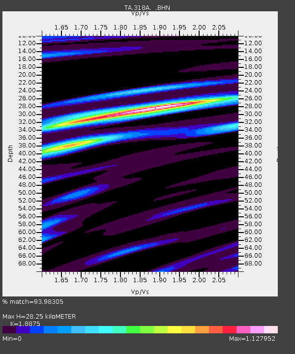
318A Bisbee, AZ, USA - Earthquake Result Viewer
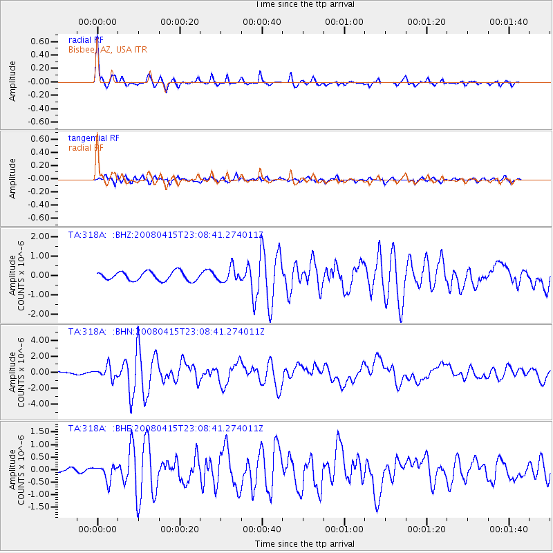
Earthquake location: Andreanof Islands, Aleutian Is.
Earthquake latitude/longitude: 51.9/-179.4
Earthquake time(UTC): 2008/04/15 (106) 22:59:51 GMT
Earthquake Depth: 10 km
Earthquake Magnitude: 6.1 MB, 6.4 MS, 6.4 MW, 6.4 MW
Earthquake Catalog/Contributor: WHDF/NEIC
Network: TA USArray Transportable Network (new EarthScope stations)
Station: 318A Bisbee, AZ, USA
Lat/Lon: 31.44 N/109.99 W
Elevation: 1576 m
Distance: 53.6 deg
Az: 83.887 deg
Baz: 313.821 deg
Ray Param: 0.066016994
Estimated Moho Depth: 28.25 km
Estimated Crust Vp/Vs: 1.89
Assumed Crust Vp: 6.182 km/s
Estimated Crust Vs: 3.275 km/s
Estimated Crust Poisson's Ratio: 0.30
Radial Match: 93.98305 %
Radial Bump: 272
Transverse Match: 76.80933 %
Transverse Bump: 400
SOD ConfigId: 2504
Insert Time: 2010-03-06 08:07:47.034 +0000
GWidth: 2.5
Max Bumps: 400
Tol: 0.001

Signal To Noise

ChannelStoNSTALTA
TA:318A: :BHN:20080415T23:08:41.274011Z7.58318427.7112895E-71.0168934E-7
TA:318A: :BHE:20080415T23:08:41.274011Z4.8847273.137708E-76.4235074E-8
TA:318A: :BHZ:20080415T23:08:41.274011Z1.65431613.7632879E-72.27483E-7
Arrivals
Ps4.2 SECOND
PpPs13 SECOND
PsPs/PpSs17 SECOND