You are here: Home > Network List > N4 - Central and EAstern US Network Stations List
> Station Y60A Bolivia, NC, USA > Earthquake Result Viewer
Y60A Bolivia, NC, USA - Earthquake Result Viewer
| Earthquake location: |
Northern Chile |
| Earthquake latitude/longitude: |
-18.9/-69.6 |
| Earthquake time(UTC): |
2018/01/21 (021) 01:06:42 GMT |
| Earthquake Depth: |
111 km |
| Earthquake Magnitude: |
6.3 Mww |
| Earthquake Catalog/Contributor: |
NEIC PDE/us |
|
| Network: |
N4 Central and EAstern US Network |
| Station: |
Y60A Bolivia, NC, USA |
| Lat/Lon: |
34.00 N/78.22 W |
| Elevation: |
7.0 m |
|
| Distance: |
53.2 deg |
| Az: |
351.079 deg |
| Baz: |
169.82 deg |
| Ray Param: |
0.06587615 |
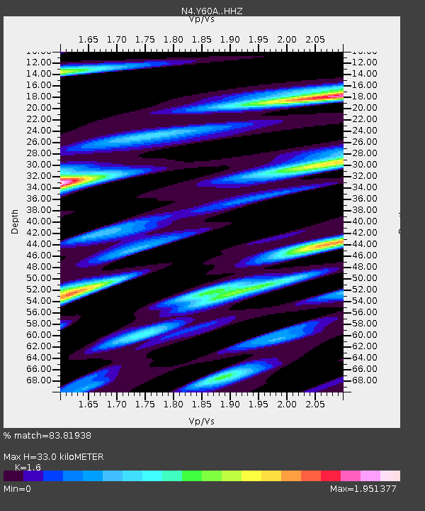
| Estimated Moho Depth: |
33.0 km |
| Estimated Crust Vp/Vs: |
1.60 |
| Assumed Crust Vp: |
6.565 km/s |
| Estimated Crust Vs: |
4.103 km/s |
| Estimated Crust Poisson's Ratio: |
0.18 |
|
| Radial Match: |
83.81938 % |
| Radial Bump: |
314 |
| Transverse Match: |
60.209484 % |
| Transverse Bump: |
400 |
| SOD ConfigId: |
13570011 |
| Insert Time: |
2019-04-29 14:46:14.324 +0000 |
| GWidth: |
2.5 |
| Max Bumps: |
400 |
| Tol: |
0.001 |
|

Signal To Noise
| Channel | StoN | STA | LTA |
| N4:Y60A: :HHZ:20180121T01:15:18.730029Z | 12.414054 | 2.5774557E-6 | 2.0762401E-7 |
| N4:Y60A: :HHN:20180121T01:15:18.730029Z | 7.2809486 | 2.3768375E-6 | 3.2644613E-7 |
| N4:Y60A: :HHE:20180121T01:15:18.730029Z | 1.1311351 | 4.0339754E-7 | 3.5663072E-7 |
| Arrivals |
| Ps | 3.2 SECOND |
| PpPs | 12 SECOND |
| PsPs/PpSs | 15 SECOND |


