You are here: Home > Network List > TA - USArray Transportable Network (new EarthScope stations) Stations List
> Station 318A Bisbee, AZ, USA > Earthquake Result Viewer
318A Bisbee, AZ, USA - Earthquake Result Viewer
| Earthquake location: |
South Of Panama |
| Earthquake latitude/longitude: |
5.0/-82.7 |
| Earthquake time(UTC): |
2008/06/17 (169) 17:42:09 GMT |
| Earthquake Depth: |
10 km |
| Earthquake Magnitude: |
5.6 MB, 5.3 MS, 5.9 MW, 5.9 MW |
| Earthquake Catalog/Contributor: |
WHDF/NEIC |
|
| Network: |
TA USArray Transportable Network (new EarthScope stations) |
| Station: |
318A Bisbee, AZ, USA |
| Lat/Lon: |
31.44 N/109.99 W |
| Elevation: |
1576 m |
|
| Distance: |
36.7 deg |
| Az: |
318.98 deg |
| Baz: |
130.096 deg |
| Ray Param: |
0.076519765 |
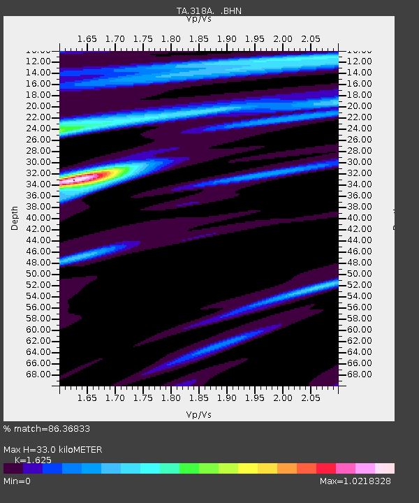
| Estimated Moho Depth: |
33.0 km |
| Estimated Crust Vp/Vs: |
1.62 |
| Assumed Crust Vp: |
6.182 km/s |
| Estimated Crust Vs: |
3.804 km/s |
| Estimated Crust Poisson's Ratio: |
0.20 |
|
| Radial Match: |
86.36833 % |
| Radial Bump: |
400 |
| Transverse Match: |
65.55188 % |
| Transverse Bump: |
400 |
| SOD ConfigId: |
2504 |
| Insert Time: |
2010-03-06 08:07:58.618 +0000 |
| GWidth: |
2.5 |
| Max Bumps: |
400 |
| Tol: |
0.001 |
|

Signal To Noise
| Channel | StoN | STA | LTA |
| TA:318A: :BHN:20080617T17:48:46.175005Z | 6.9193563 | 7.3007396E-7 | 1.0551184E-7 |
| TA:318A: :BHE:20080617T17:48:46.175005Z | 4.2011504 | 2.596003E-7 | 6.1792676E-8 |
| TA:318A: :BHZ:20080617T17:48:46.175005Z | 3.314924 | 2.7043117E-7 | 8.1579905E-8 |
| Arrivals |
| Ps | 3.6 SECOND |
| PpPs | 13 SECOND |
| PsPs/PpSs | 17 SECOND |


