You are here: Home > Network List > TA - USArray Transportable Network (new EarthScope stations) Stations List
> Station 318A Bisbee, AZ, USA > Earthquake Result Viewer
318A Bisbee, AZ, USA - Earthquake Result Viewer
| Earthquake location: |
Eastern Honshu, Japan |
| Earthquake latitude/longitude: |
39.8/141.5 |
| Earthquake time(UTC): |
2008/07/23 (205) 15:26:19 GMT |
| Earthquake Depth: |
108 km |
| Earthquake Magnitude: |
6.6 MB, 6.8 MW, 6.8 MW |
| Earthquake Catalog/Contributor: |
WHDF/NEIC |
|
| Network: |
TA USArray Transportable Network (new EarthScope stations) |
| Station: |
318A Bisbee, AZ, USA |
| Lat/Lon: |
31.44 N/109.99 W |
| Elevation: |
1576 m |
|
| Distance: |
83.0 deg |
| Az: |
54.727 deg |
| Baz: |
312.624 deg |
| Ray Param: |
0.046245083 |
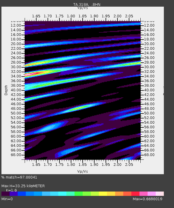
| Estimated Moho Depth: |
33.25 km |
| Estimated Crust Vp/Vs: |
1.60 |
| Assumed Crust Vp: |
6.182 km/s |
| Estimated Crust Vs: |
3.864 km/s |
| Estimated Crust Poisson's Ratio: |
0.18 |
|
| Radial Match: |
97.88041 % |
| Radial Bump: |
400 |
| Transverse Match: |
93.419365 % |
| Transverse Bump: |
400 |
| SOD ConfigId: |
2504 |
| Insert Time: |
2010-03-06 08:08:12.046 +0000 |
| GWidth: |
2.5 |
| Max Bumps: |
400 |
| Tol: |
0.001 |
|

Signal To Noise
| Channel | StoN | STA | LTA |
| TA:318A: :BHN:20080723T15:38:02.173999Z | 32.427094 | 2.9729683E-6 | 9.168161E-8 |
| TA:318A: :BHE:20080723T15:38:02.173999Z | 6.638158 | 6.745865E-7 | 1.0162255E-7 |
| TA:318A: :BHZ:20080723T15:38:02.173999Z | 8.270012 | 8.2589617E-7 | 9.986638E-8 |
| Arrivals |
| Ps | 3.3 SECOND |
| PpPs | 14 SECOND |
| PsPs/PpSs | 17 SECOND |


