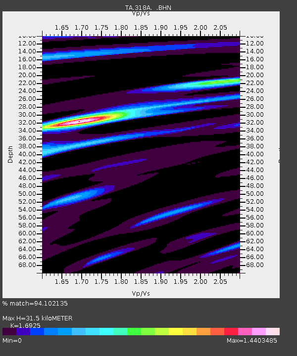
318A Bisbee, AZ, USA - Earthquake Result Viewer
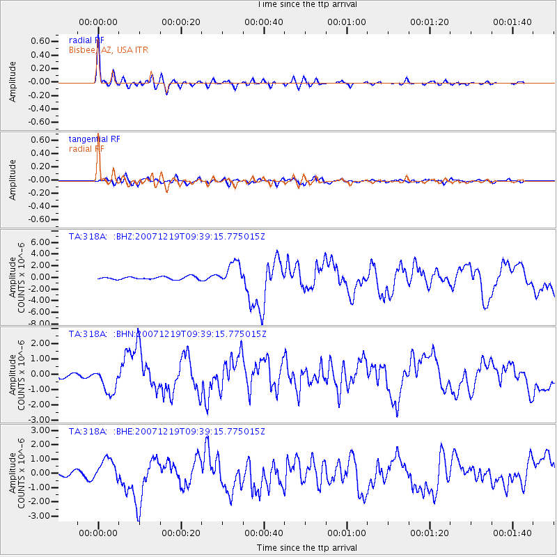
Earthquake location: Andreanof Islands, Aleutian Is.
Earthquake latitude/longitude: 51.4/-179.5
Earthquake time(UTC): 2007/12/19 (353) 09:30:27 GMT
Earthquake Depth: 29 km
Earthquake Magnitude: 6.4 MB, 7.1 MS, 7.1 MW, 7.0 MW
Earthquake Catalog/Contributor: WHDF/NEIC
Network: TA USArray Transportable Network (new EarthScope stations)
Station: 318A Bisbee, AZ, USA
Lat/Lon: 31.44 N/109.99 W
Elevation: 1576 m
Distance: 53.7 deg
Az: 83.408 deg
Baz: 313.228 deg
Ray Param: 0.06586022
Estimated Moho Depth: 31.5 km
Estimated Crust Vp/Vs: 1.69
Assumed Crust Vp: 6.182 km/s
Estimated Crust Vs: 3.653 km/s
Estimated Crust Poisson's Ratio: 0.23
Radial Match: 94.102135 %
Radial Bump: 373
Transverse Match: 77.71846 %
Transverse Bump: 400
SOD ConfigId: 2564
Insert Time: 2010-03-06 08:08:34.293 +0000
GWidth: 2.5
Max Bumps: 400
Tol: 0.001

Signal To Noise

ChannelStoNSTALTA
TA:318A: :BHN:20071219T09:39:15.775015Z4.8456758.741999E-71.8040828E-7
TA:318A: :BHE:20071219T09:39:15.775015Z4.6385428.5054563E-71.8336485E-7
TA:318A: :BHZ:20071219T09:39:15.775015Z8.1654991.973577E-62.4169702E-7
Arrivals
Ps3.7 SECOND
PpPs13 SECOND
PsPs/PpSs17 SECOND