You are here: Home > Network List > TA - USArray Transportable Network (new EarthScope stations) Stations List
> Station 318A Bisbee, AZ, USA > Earthquake Result Viewer
318A Bisbee, AZ, USA - Earthquake Result Viewer
| Earthquake location: |
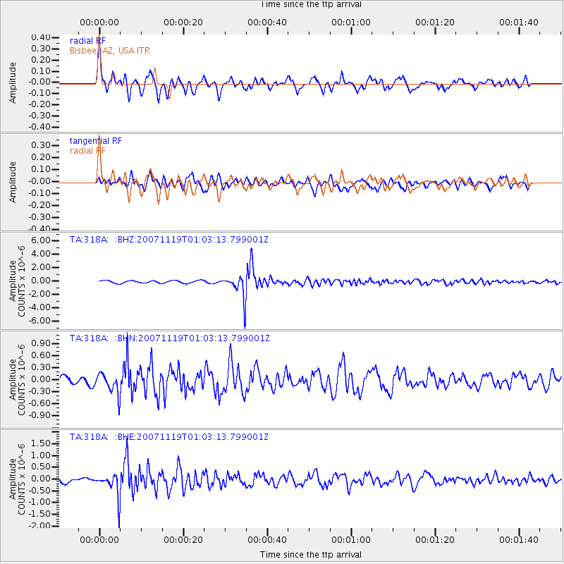
Fiji Islands Region |
| Earthquake latitude/longitude: |
-21.2/-178.8 |
| Earthquake time(UTC): |
2007/11/19 (323) 00:52:12 GMT |
| Earthquake Depth: |
558 km |
| Earthquake Magnitude: |
6.2 MB, 6.3 MW, 6.3 MW |
| Earthquake Catalog/Contributor: |
WHDF/NEIC |
|
| Network: |
TA USArray Transportable Network (new EarthScope stations) |
| Station: |
318A Bisbee, AZ, USA |
| Lat/Lon: |
31.44 N/109.99 W |
| Elevation: |
1576 m |
|
| Distance: |
84.1 deg |
| Az: |
53.217 deg |
| Baz: |
240.98 deg |
| Ray Param: |
0.044088684 |
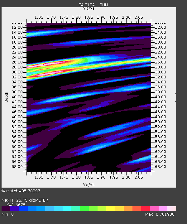
| Estimated Moho Depth: |
26.75 km |
| Estimated Crust Vp/Vs: |
1.67 |
| Assumed Crust Vp: |
6.182 km/s |
| Estimated Crust Vs: |
3.708 km/s |
| Estimated Crust Poisson's Ratio: |
0.22 |
|
| Radial Match: |
85.78297 % |
| Radial Bump: |
400 |
| Transverse Match: |
69.70889 % |
| Transverse Bump: |
400 |
| SOD ConfigId: |
2564 |
| Insert Time: |
2010-03-06 08:08:46.045 +0000 |
| GWidth: |
2.5 |
| Max Bumps: |
400 |
| Tol: |
0.001 |
|
Signal To Noise
| Channel | StoN | STA | LTA |
| TA:318A: :BHN:20071119T01:03:13.799001Z | 2.5326598 | 2.5831798E-7 | 1.0199474E-7 |
| TA:318A: :BHE:20071119T01:03:13.799001Z | 3.6627483 | 5.121968E-7 | 1.3983946E-7 |
| TA:318A: :BHZ:20071119T01:03:13.799001Z | 9.238478 | 1.8088645E-6 | 1.9579682E-7 |
| Arrivals |
| Ps | 3.0 SECOND |
| PpPs | 11 SECOND |
| PsPs/PpSs | 14 SECOND |


