You are here: Home > Network List > TA - USArray Transportable Network (new EarthScope stations) Stations List
> Station 318A Bisbee, AZ, USA > Earthquake Result Viewer
318A Bisbee, AZ, USA - Earthquake Result Viewer
| Earthquake location: |
Volcano Islands, Japan Region |
| Earthquake latitude/longitude: |
22.0/142.7 |
| Earthquake time(UTC): |
2007/09/28 (271) 13:38:59 GMT |
| Earthquake Depth: |
276 km |
| Earthquake Magnitude: |
6.7 MB, 7.4 MW, 7.4 MW |
| Earthquake Catalog/Contributor: |
WHDF/NEIC |
|
| Network: |
TA USArray Transportable Network (new EarthScope stations) |
| Station: |
318A Bisbee, AZ, USA |
| Lat/Lon: |
31.44 N/109.99 W |
| Elevation: |
1576 m |
|
| Distance: |
92.5 deg |
| Az: |
54.745 deg |
| Baz: |
297.552 deg |
| Ray Param: |
0.04127517 |
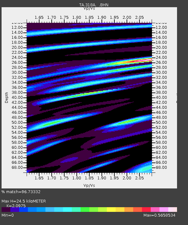
| Estimated Moho Depth: |
24.5 km |
| Estimated Crust Vp/Vs: |
2.10 |
| Assumed Crust Vp: |
6.182 km/s |
| Estimated Crust Vs: |
2.947 km/s |
| Estimated Crust Poisson's Ratio: |
0.35 |
|
| Radial Match: |
96.73332 % |
| Radial Bump: |
355 |
| Transverse Match: |
81.99817 % |
| Transverse Bump: |
400 |
| SOD ConfigId: |
2564 |
| Insert Time: |
2010-03-06 08:08:59.134 +0000 |
| GWidth: |
2.5 |
| Max Bumps: |
400 |
| Tol: |
0.001 |
|
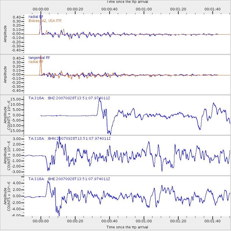
Signal To Noise
| Channel | StoN | STA | LTA |
| TA:318A: :BHN:20070928T13:51:07.974011Z | 14.111809 | 1.1262115E-6 | 7.980632E-8 |
| TA:318A: :BHE:20070928T13:51:07.974011Z | 24.874037 | 2.0504501E-6 | 8.2433345E-8 |
| TA:318A: :BHZ:20070928T13:51:07.974011Z | 59.855385 | 7.0667047E-6 | 1.1806297E-7 |
| Arrivals |
| Ps | 4.4 SECOND |
| PpPs | 12 SECOND |
| PsPs/PpSs | 17 SECOND |


