You are here: Home > Network List > TA - USArray Transportable Network (new EarthScope stations) Stations List
> Station 318A Bisbee, AZ, USA > Earthquake Result Viewer
318A Bisbee, AZ, USA - Earthquake Result Viewer
| Earthquake location: |
Southeast Of Loyalty Islands |
| Earthquake latitude/longitude: |
-21.2/169.4 |
| Earthquake time(UTC): |
2007/09/28 (271) 01:01:48 GMT |
| Earthquake Depth: |
10 km |
| Earthquake Magnitude: |
5.8 MB, 6.4 MS, 6.3 MW, 6.2 MW |
| Earthquake Catalog/Contributor: |
WHDF/NEIC |
|
| Network: |
TA USArray Transportable Network (new EarthScope stations) |
| Station: |
318A Bisbee, AZ, USA |
| Lat/Lon: |
31.44 N/109.99 W |
| Elevation: |
1576 m |
|
| Distance: |
93.3 deg |
| Az: |
57.647 deg |
| Baz: |
247.251 deg |
| Ray Param: |
0.041293893 |
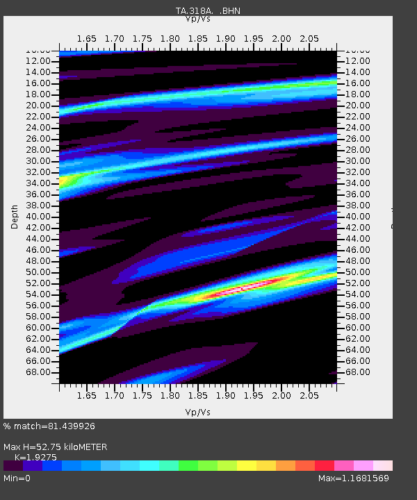
| Estimated Moho Depth: |
52.75 km |
| Estimated Crust Vp/Vs: |
1.93 |
| Assumed Crust Vp: |
6.182 km/s |
| Estimated Crust Vs: |
3.207 km/s |
| Estimated Crust Poisson's Ratio: |
0.32 |
|
| Radial Match: |
81.439926 % |
| Radial Bump: |
367 |
| Transverse Match: |
71.63839 % |
| Transverse Bump: |
400 |
| SOD ConfigId: |
2564 |
| Insert Time: |
2010-03-06 08:09:02.361 +0000 |
| GWidth: |
2.5 |
| Max Bumps: |
400 |
| Tol: |
0.001 |
|
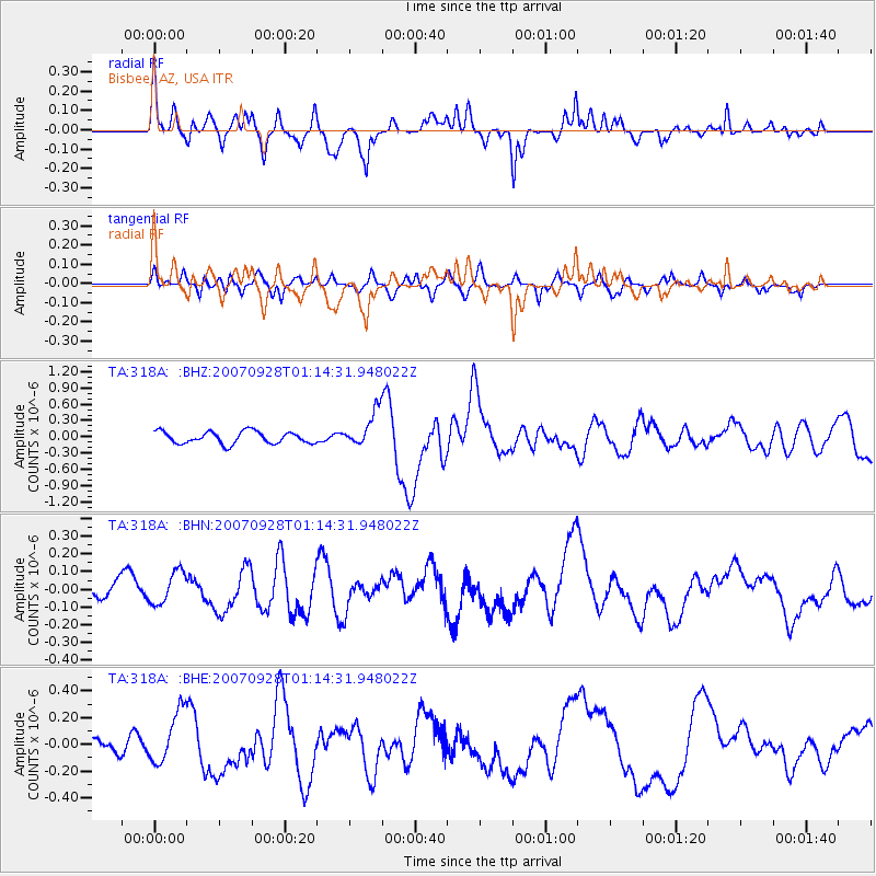
Signal To Noise
| Channel | StoN | STA | LTA |
| TA:318A: :BHN:20070928T01:14:31.948022Z | 1.6278177 | 9.30989E-8 | 5.719246E-8 |
| TA:318A: :BHE:20070928T01:14:31.948022Z | 4.964383 | 1.9963507E-7 | 4.021347E-8 |
| TA:318A: :BHZ:20070928T01:14:31.948022Z | 2.952609 | 3.2908082E-7 | 1.1145424E-7 |
| Arrivals |
| Ps | 8.1 SECOND |
| PpPs | 25 SECOND |
| PsPs/PpSs | 33 SECOND |


