You are here: Home > Network List > TA - USArray Transportable Network (new EarthScope stations) Stations List
> Station M31M Drury Creek, Yukon, CA > Earthquake Result Viewer
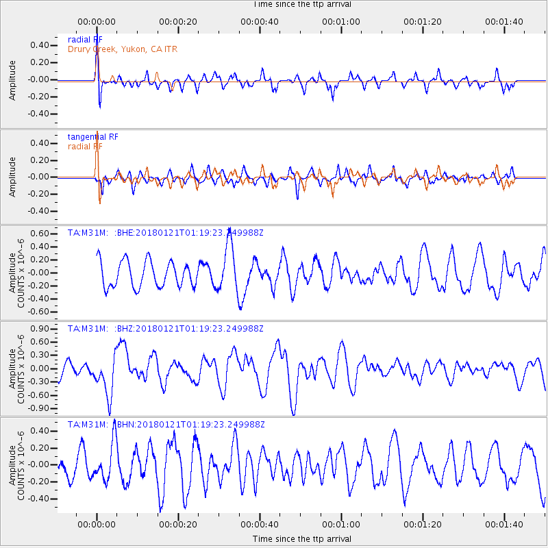
M31M Drury Creek, Yukon, CA - Earthquake Result Viewer
*The percent match for this event was below the threshold and hence no stack was calculated.
| Earthquake location: |
Northern Chile |
| Earthquake latitude/longitude: |
-18.9/-69.6 |
| Earthquake time(UTC): |
2018/01/21 (021) 01:06:42 GMT |
| Earthquake Depth: |
111 km |
| Earthquake Magnitude: |
6.3 Mww |
| Earthquake Catalog/Contributor: |
NEIC PDE/us |
|
| Network: |
TA USArray Transportable Network (new EarthScope stations) |
| Station: |
M31M Drury Creek, Yukon, CA |
| Lat/Lon: |
62.20 N/134.39 W |
| Elevation: |
639 m |
|
| Distance: |
95.5 deg |
| Az: |
334.784 deg |
| Baz: |
120.636 deg |
| Ray Param: |
$rayparam |
*The percent match for this event was below the threshold and hence was not used in the summary stack. |
|
| Radial Match: |
54.658627 % |
| Radial Bump: |
400 |
| Transverse Match: |
64.75176 % |
| Transverse Bump: |
348 |
| SOD ConfigId: |
13570011 |
| Insert Time: |
2019-04-29 14:49:21.803 +0000 |
| GWidth: |
2.5 |
| Max Bumps: |
400 |
| Tol: |
0.001 |
|
Signal To Noise
| Channel | StoN | STA | LTA |
| TA:M31M: :BHZ:20180121T01:19:23.249988Z | 2.629922 | 4.5996217E-7 | 1.7489575E-7 |
| TA:M31M: :BHN:20180121T01:19:23.249988Z | 1.5490927 | 2.363445E-7 | 1.5256964E-7 |
| TA:M31M: :BHE:20180121T01:19:23.249988Z | 1.8334721 | 3.6146534E-7 | 1.9714798E-7 |
| Arrivals |
| Ps | |
| PpPs | |
| PsPs/PpSs | |


