You are here: Home > Network List > TA - USArray Transportable Network (new EarthScope stations) Stations List
> Station P52A Corning, OH, USA > Earthquake Result Viewer
P52A Corning, OH, USA - Earthquake Result Viewer
| Earthquake location: |
Northern Chile |
| Earthquake latitude/longitude: |
-18.9/-69.6 |
| Earthquake time(UTC): |
2018/01/21 (021) 01:06:42 GMT |
| Earthquake Depth: |
111 km |
| Earthquake Magnitude: |
6.3 Mww |
| Earthquake Catalog/Contributor: |
NEIC PDE/us |
|
| Network: |
TA USArray Transportable Network (new EarthScope stations) |
| Station: |
P52A Corning, OH, USA |
| Lat/Lon: |
39.63 N/82.13 W |
| Elevation: |
293 m |
|
| Distance: |
59.4 deg |
| Az: |
348.786 deg |
| Baz: |
166.206 deg |
| Ray Param: |
0.06190112 |
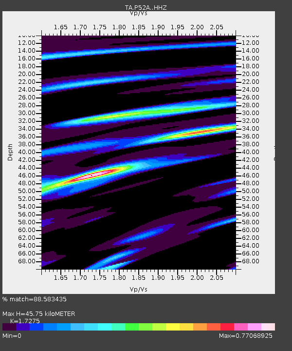
| Estimated Moho Depth: |
45.75 km |
| Estimated Crust Vp/Vs: |
1.73 |
| Assumed Crust Vp: |
6.232 km/s |
| Estimated Crust Vs: |
3.607 km/s |
| Estimated Crust Poisson's Ratio: |
0.25 |
|
| Radial Match: |
88.583435 % |
| Radial Bump: |
319 |
| Transverse Match: |
71.48516 % |
| Transverse Bump: |
400 |
| SOD ConfigId: |
13570011 |
| Insert Time: |
2019-04-29 14:49:32.840 +0000 |
| GWidth: |
2.5 |
| Max Bumps: |
400 |
| Tol: |
0.001 |
|

Signal To Noise
| Channel | StoN | STA | LTA |
| TA:P52A: :HHZ:20180121T01:16:02.299976Z | 10.67765 | 2.4048256E-6 | 2.2522049E-7 |
| TA:P52A: :HHN:20180121T01:16:02.299976Z | 7.0585804 | 1.1383577E-6 | 1.612729E-7 |
| TA:P52A: :HHE:20180121T01:16:02.299976Z | 2.0701306 | 4.3913485E-7 | 2.1212905E-7 |
| Arrivals |
| Ps | 5.6 SECOND |
| PpPs | 19 SECOND |
| PsPs/PpSs | 25 SECOND |


