You are here: Home > Network List > TA - USArray Transportable Network (new EarthScope stations) Stations List
> Station 318A Bisbee, AZ, USA > Earthquake Result Viewer
318A Bisbee, AZ, USA - Earthquake Result Viewer
| Earthquake location: |
South Of Fiji Islands |
| Earthquake latitude/longitude: |
-26.2/-177.7 |
| Earthquake time(UTC): |
2007/07/17 (198) 09:39:27 GMT |
| Earthquake Depth: |
10 km |
| Earthquake Magnitude: |
5.7 MB, 6.0 MS, 6.1 MW, 6.0 MW |
| Earthquake Catalog/Contributor: |
WHDF/NEIC |
|
| Network: |
TA USArray Transportable Network (new EarthScope stations) |
| Station: |
318A Bisbee, AZ, USA |
| Lat/Lon: |
31.44 N/109.99 W |
| Elevation: |
1576 m |
|
| Distance: |
86.4 deg |
| Az: |
52.437 deg |
| Baz: |
236.424 deg |
| Ray Param: |
0.044077292 |
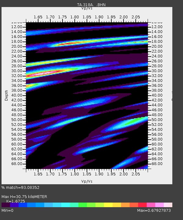
| Estimated Moho Depth: |
30.75 km |
| Estimated Crust Vp/Vs: |
1.67 |
| Assumed Crust Vp: |
6.182 km/s |
| Estimated Crust Vs: |
3.696 km/s |
| Estimated Crust Poisson's Ratio: |
0.22 |
|
| Radial Match: |
93.08352 % |
| Radial Bump: |
398 |
| Transverse Match: |
76.89621 % |
| Transverse Bump: |
400 |
| SOD ConfigId: |
2564 |
| Insert Time: |
2010-03-06 08:09:29.411 +0000 |
| GWidth: |
2.5 |
| Max Bumps: |
400 |
| Tol: |
0.001 |
|

Signal To Noise
| Channel | StoN | STA | LTA |
| TA:318A: :BHN:20070717T09:51:38.750002Z | 1.4146696 | 5.9266394E-8 | 4.1894157E-8 |
| TA:318A: :BHE:20070717T09:51:38.750002Z | 0.934192 | 4.661314E-8 | 4.9896745E-8 |
| TA:318A: :BHZ:20070717T09:51:38.750002Z | 1.3358765 | 8.606793E-8 | 6.442806E-8 |
| Arrivals |
| Ps | 3.4 SECOND |
| PpPs | 13 SECOND |
| PsPs/PpSs | 16 SECOND |


