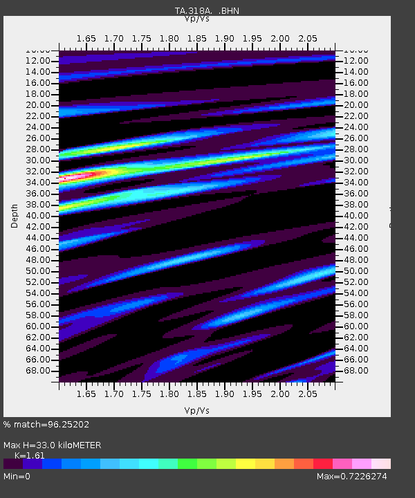
318A Bisbee, AZ, USA - Earthquake Result Viewer
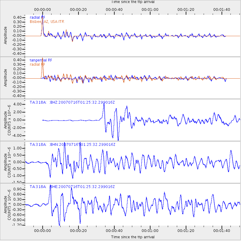
Earthquake location: Near West Coast Of Honshu, Japan
Earthquake latitude/longitude: 37.5/138.4
Earthquake time(UTC): 2007/07/16 (197) 01:13:22 GMT
Earthquake Depth: 12 km
Earthquake Magnitude: 6.5 MB, 6.4 MS, 6.6 MW, 6.5 MW
Earthquake Catalog/Contributor: WHDF/NEIC
Network: TA USArray Transportable Network (new EarthScope stations)
Station: 318A Bisbee, AZ, USA
Lat/Lon: 31.44 N/109.99 W
Elevation: 1576 m
Distance: 86.3 deg
Az: 52.809 deg
Baz: 312.193 deg
Ray Param: 0.044172015
Estimated Moho Depth: 33.0 km
Estimated Crust Vp/Vs: 1.61
Assumed Crust Vp: 6.182 km/s
Estimated Crust Vs: 3.84 km/s
Estimated Crust Poisson's Ratio: 0.19
Radial Match: 96.25202 %
Radial Bump: 288
Transverse Match: 86.70806 %
Transverse Bump: 400
SOD ConfigId: 2564
Insert Time: 2010-03-06 08:09:37.003 +0000
GWidth: 2.5
Max Bumps: 400
Tol: 0.001

Signal To Noise

ChannelStoNSTALTA
TA:318A: :BHN:20070716T01:25:32.299016Z7.45537333.6394252E-74.8816137E-8
TA:318A: :BHE:20070716T01:25:32.299016Z8.1040263.9636248E-74.8909328E-8
TA:318A: :BHZ:20070716T01:25:32.299016Z26.2904851.488181E-65.6605305E-8
Arrivals
Ps3.3 SECOND
PpPs14 SECOND
PsPs/PpSs17 SECOND