You are here: Home > Network List > TX - Texas Seismological Network Stations List
> Station SN06 Snyder 6 > Earthquake Result Viewer
SN06 Snyder 6 - Earthquake Result Viewer
| Earthquake location: |
Northern Chile |
| Earthquake latitude/longitude: |
-18.9/-69.6 |
| Earthquake time(UTC): |
2018/01/21 (021) 01:06:42 GMT |
| Earthquake Depth: |
111 km |
| Earthquake Magnitude: |
6.3 Mww |
| Earthquake Catalog/Contributor: |
NEIC PDE/us |
|
| Network: |
TX Texas Seismological Network |
| Station: |
SN06 Snyder 6 |
| Lat/Lon: |
32.88 N/100.93 W |
| Elevation: |
769 m |
|
| Distance: |
59.5 deg |
| Az: |
329.512 deg |
| Baz: |
145.189 deg |
| Ray Param: |
0.061791323 |
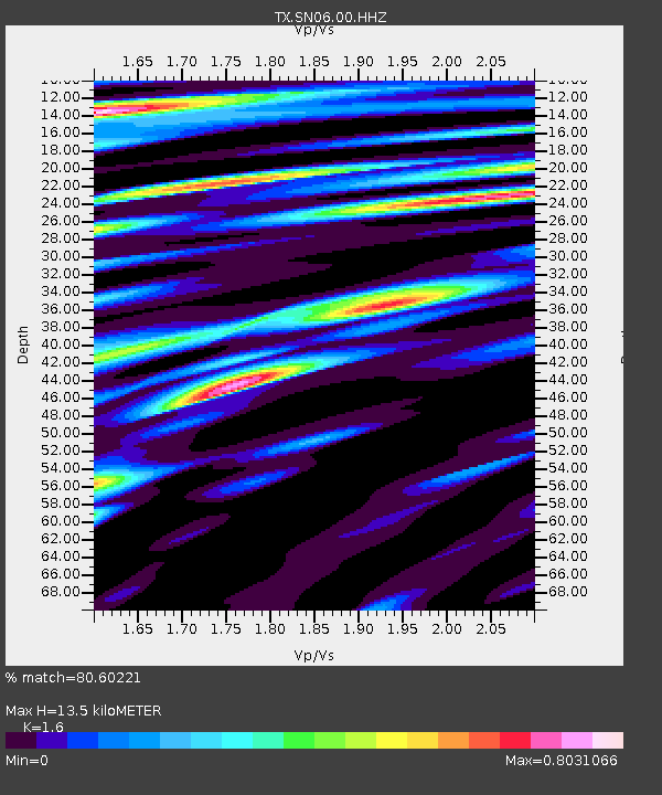
| Estimated Moho Depth: |
13.5 km |
| Estimated Crust Vp/Vs: |
1.60 |
| Assumed Crust Vp: |
6.426 km/s |
| Estimated Crust Vs: |
4.016 km/s |
| Estimated Crust Poisson's Ratio: |
0.18 |
|
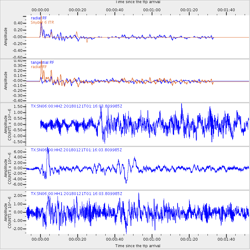
| Radial Match: |
80.60221 % |
| Radial Bump: |
400 |
| Transverse Match: |
72.23136 % |
| Transverse Bump: |
400 |
| SOD ConfigId: |
13570011 |
| Insert Time: |
2019-04-29 14:50:06.871 +0000 |
| GWidth: |
2.5 |
| Max Bumps: |
400 |
| Tol: |
0.001 |
|
Signal To Noise
| Channel | StoN | STA | LTA |
| TX:SN06:00:HHZ:20180121T01:16:03.809985Z | 18.131552 | 3.1884563E-6 | 1.7585126E-7 |
| TX:SN06:00:HH1:20180121T01:16:03.809985Z | 2.9504457 | 9.0870066E-7 | 3.079876E-7 |
| TX:SN06:00:HH2:20180121T01:16:03.809985Z | 2.3323083 | 6.158485E-7 | 2.6405107E-7 |
| Arrivals |
| Ps | 1.3 SECOND |
| PpPs | 5.2 SECOND |
| PsPs/PpSs | 6.5 SECOND |


