You are here: Home > Network List > JP - Japan Meteorological Agency Seismic Network Stations List
> Station JGF Gifu Kurokawa > Earthquake Result Viewer
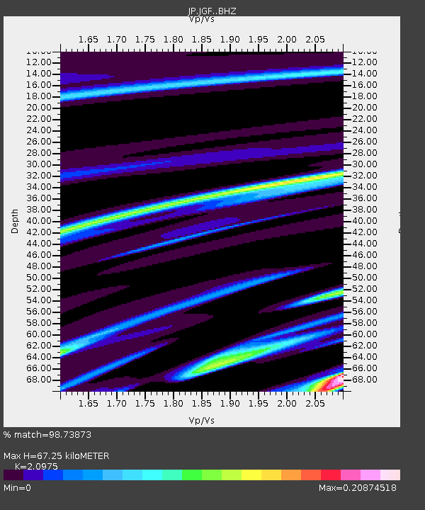
JGF Gifu Kurokawa - Earthquake Result Viewer
| Earthquake location: |
Java, Indonesia |
| Earthquake latitude/longitude: |
-7.2/105.9 |
| Earthquake time(UTC): |
2018/01/23 (023) 06:34:54 GMT |
| Earthquake Depth: |
44 km |
| Earthquake Magnitude: |
6.0 Mww |
| Earthquake Catalog/Contributor: |
NEIC PDE/us |
|
| Network: |
JP Japan Meteorological Agency Seismic Network |
| Station: |
JGF Gifu Kurokawa |
| Lat/Lon: |
35.60 N/137.35 E |
| Elevation: |
580 m |
|
| Distance: |
51.8 deg |
| Az: |
32.716 deg |
| Baz: |
221.154 deg |
| Ray Param: |
0.0670411 |
| Estimated Moho Depth: |
67.25 km |
| Estimated Crust Vp/Vs: |
2.10 |
| Assumed Crust Vp: |
6.461 km/s |
| Estimated Crust Vs: |
3.081 km/s |
| Estimated Crust Poisson's Ratio: |
0.35 |
|
| Radial Match: |
98.73873 % |
| Radial Bump: |
126 |
| Transverse Match: |
90.94826 % |
| Transverse Bump: |
388 |
| SOD ConfigId: |
13570011 |
| Insert Time: |
2019-04-29 14:53:03.096 +0000 |
| GWidth: |
2.5 |
| Max Bumps: |
400 |
| Tol: |
0.001 |
|

Signal To Noise
| Channel | StoN | STA | LTA |
| JP:JGF: :BHZ:20180123T06:43:27.450022Z | 0.24165139 | 7.678238E-9 | 3.1774025E-8 |
| JP:JGF: :BHN:20180123T06:43:27.450022Z | 0.20612869 | 6.5780488E-9 | 3.191234E-8 |
| JP:JGF: :BHE:20180123T06:43:27.450022Z | 0.21259007 | 7.6115425E-9 | 3.5803847E-8 |
| Arrivals |
| Ps | 12 SECOND |
| PpPs | 31 SECOND |
| PsPs/PpSs | 43 SECOND |


