You are here: Home > Network List > 5H - Central Virginia and South Carolina seismic monitoring experiment Stations List
> Station BEAR Cumberland S.F., VA > Earthquake Result Viewer
BEAR Cumberland S.F., VA - Earthquake Result Viewer
| Earthquake location: |
Gulf Of Alaska |
| Earthquake latitude/longitude: |
56.0/-149.1 |
| Earthquake time(UTC): |
2018/01/23 (023) 09:31:42 GMT |
| Earthquake Depth: |
25 km |
| Earthquake Magnitude: |
7.9 Mww |
| Earthquake Catalog/Contributor: |
NEIC PDE/us |
|
| Network: |
5H Central Virginia and South Carolina seismic monitoring experiment |
| Station: |
BEAR Cumberland S.F., VA |
| Lat/Lon: |
37.53 N/78.29 W |
| Elevation: |
107 m |
|
| Distance: |
49.5 deg |
| Az: |
80.637 deg |
| Baz: |
315.863 deg |
| Ray Param: |
0.06859586 |
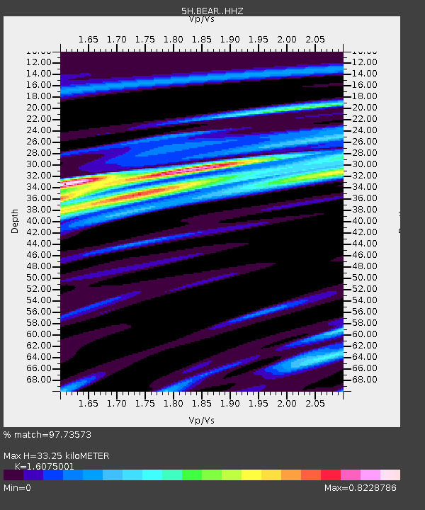
| Estimated Moho Depth: |
33.25 km |
| Estimated Crust Vp/Vs: |
1.61 |
| Assumed Crust Vp: |
6.419 km/s |
| Estimated Crust Vs: |
3.993 km/s |
| Estimated Crust Poisson's Ratio: |
0.18 |
|
| Radial Match: |
97.73573 % |
| Radial Bump: |
338 |
| Transverse Match: |
88.71784 % |
| Transverse Bump: |
400 |
| SOD ConfigId: |
13570011 |
| Insert Time: |
2019-04-29 14:54:43.109 +0000 |
| GWidth: |
2.5 |
| Max Bumps: |
400 |
| Tol: |
0.001 |
|

Signal To Noise
| Channel | StoN | STA | LTA |
| 5H:BEAR: :HHZ:20180123T09:40:00.749998Z | 11.825433 | 3.4928346E-6 | 2.9536633E-7 |
| 5H:BEAR: :HHN:20180123T09:40:00.749998Z | 3.7803497 | 1.2296235E-6 | 3.2526714E-7 |
| 5H:BEAR: :HHE:20180123T09:40:00.749998Z | 0.6712182 | 4.6320883E-7 | 6.901017E-7 |
| Arrivals |
| Ps | 3.4 SECOND |
| PpPs | 13 SECOND |
| PsPs/PpSs | 16 SECOND |


