You are here: Home > Network List > 5H - Central Virginia and South Carolina seismic monitoring experiment Stations List
> Station GOOD Gooden Farm > Earthquake Result Viewer
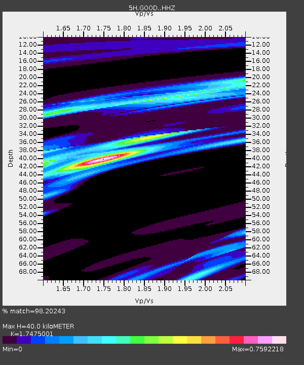
GOOD Gooden Farm - Earthquake Result Viewer
| Earthquake location: |
Gulf Of Alaska |
| Earthquake latitude/longitude: |
56.0/-149.1 |
| Earthquake time(UTC): |
2018/01/23 (023) 09:31:42 GMT |
| Earthquake Depth: |
25 km |
| Earthquake Magnitude: |
7.9 Mww |
| Earthquake Catalog/Contributor: |
NEIC PDE/us |
|
| Network: |
5H Central Virginia and South Carolina seismic monitoring experiment |
| Station: |
GOOD Gooden Farm |
| Lat/Lon: |
37.60 N/78.64 W |
| Elevation: |
175 m |
|
| Distance: |
49.3 deg |
| Az: |
80.837 deg |
| Baz: |
315.777 deg |
| Ray Param: |
0.06875547 |
| Estimated Moho Depth: |
40.0 km |
| Estimated Crust Vp/Vs: |
1.75 |
| Assumed Crust Vp: |
6.419 km/s |
| Estimated Crust Vs: |
3.673 km/s |
| Estimated Crust Poisson's Ratio: |
0.26 |
|
| Radial Match: |
98.20243 % |
| Radial Bump: |
262 |
| Transverse Match: |
93.49582 % |
| Transverse Bump: |
400 |
| SOD ConfigId: |
13570011 |
| Insert Time: |
2019-04-29 14:54:49.239 +0000 |
| GWidth: |
2.5 |
| Max Bumps: |
400 |
| Tol: |
0.001 |
|

Signal To Noise
| Channel | StoN | STA | LTA |
| 5H:GOOD: :HHZ:20180123T09:39:58.834989Z | 10.3315525 | 3.6403153E-6 | 3.523493E-7 |
| 5H:GOOD: :HHN:20180123T09:39:58.834989Z | 5.8466883 | 1.8433066E-6 | 3.152736E-7 |
| 5H:GOOD: :HHE:20180123T09:39:58.834989Z | 2.4459145 | 1.193993E-6 | 4.881581E-7 |
| Arrivals |
| Ps | 4.9 SECOND |
| PpPs | 16 SECOND |
| PsPs/PpSs | 21 SECOND |


