You are here: Home > Network List > 5H - Central Virginia and South Carolina seismic monitoring experiment Stations List
> Station NORA Yanceyville, VA > Earthquake Result Viewer
NORA Yanceyville, VA - Earthquake Result Viewer
| Earthquake location: |
Gulf Of Alaska |
| Earthquake latitude/longitude: |
56.0/-149.1 |
| Earthquake time(UTC): |
2018/01/23 (023) 09:31:42 GMT |
| Earthquake Depth: |
25 km |
| Earthquake Magnitude: |
7.9 Mww |
| Earthquake Catalog/Contributor: |
NEIC PDE/us |
|
| Network: |
5H Central Virginia and South Carolina seismic monitoring experiment |
| Station: |
NORA Yanceyville, VA |
| Lat/Lon: |
37.92 N/77.98 W |
| Elevation: |
133 m |
|
| Distance: |
49.4 deg |
| Az: |
80.051 deg |
| Baz: |
315.668 deg |
| Ray Param: |
0.06866692 |
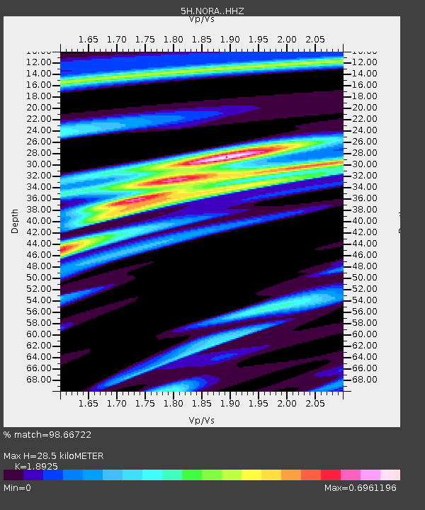
| Estimated Moho Depth: |
28.5 km |
| Estimated Crust Vp/Vs: |
1.89 |
| Assumed Crust Vp: |
6.565 km/s |
| Estimated Crust Vs: |
3.469 km/s |
| Estimated Crust Poisson's Ratio: |
0.31 |
|
| Radial Match: |
98.66722 % |
| Radial Bump: |
234 |
| Transverse Match: |
96.08728 % |
| Transverse Bump: |
400 |
| SOD ConfigId: |
13570011 |
| Insert Time: |
2019-04-29 14:54:52.710 +0000 |
| GWidth: |
2.5 |
| Max Bumps: |
400 |
| Tol: |
0.001 |
|

Signal To Noise
| Channel | StoN | STA | LTA |
| 5H:NORA: :HHZ:20180123T09:39:59.899991Z | 10.019142 | 3.136909E-6 | 3.130916E-7 |
| 5H:NORA: :HHN:20180123T09:39:59.899991Z | 6.7503495 | 1.5305619E-6 | 2.2673817E-7 |
| 5H:NORA: :HHE:20180123T09:39:59.899991Z | 4.198907 | 7.953648E-7 | 1.8942187E-7 |
| Arrivals |
| Ps | 4.1 SECOND |
| PpPs | 12 SECOND |
| PsPs/PpSs | 16 SECOND |


