You are here: Home > Network List > 5H - Central Virginia and South Carolina seismic monitoring experiment Stations List
> Station PWTN Powhatan W.M.A., VA > Earthquake Result Viewer
PWTN Powhatan W.M.A., VA - Earthquake Result Viewer
| Earthquake location: |
Gulf Of Alaska |
| Earthquake latitude/longitude: |
56.0/-149.1 |
| Earthquake time(UTC): |
2018/01/23 (023) 09:31:42 GMT |
| Earthquake Depth: |
25 km |
| Earthquake Magnitude: |
7.9 Mww |
| Earthquake Catalog/Contributor: |
NEIC PDE/us |
|
| Network: |
5H Central Virginia and South Carolina seismic monitoring experiment |
| Station: |
PWTN Powhatan W.M.A., VA |
| Lat/Lon: |
37.53 N/77.99 W |
| Elevation: |
99 m |
|
| Distance: |
49.7 deg |
| Az: |
80.408 deg |
| Baz: |
315.897 deg |
| Ray Param: |
0.06849185 |
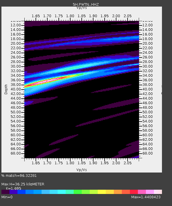
| Estimated Moho Depth: |
36.25 km |
| Estimated Crust Vp/Vs: |
1.70 |
| Assumed Crust Vp: |
6.565 km/s |
| Estimated Crust Vs: |
3.873 km/s |
| Estimated Crust Poisson's Ratio: |
0.23 |
|
| Radial Match: |
96.32281 % |
| Radial Bump: |
229 |
| Transverse Match: |
90.61201 % |
| Transverse Bump: |
400 |
| SOD ConfigId: |
13570011 |
| Insert Time: |
2019-04-29 14:54:54.475 +0000 |
| GWidth: |
2.5 |
| Max Bumps: |
400 |
| Tol: |
0.001 |
|

Signal To Noise
| Channel | StoN | STA | LTA |
| 5H:PWTN: :HHZ:20180123T09:40:01.994993Z | 14.345501 | 3.2830335E-6 | 2.2885457E-7 |
| 5H:PWTN: :HHN:20180123T09:40:01.994993Z | 2.8505943 | 2.9227467E-6 | 1.0253113E-6 |
| 5H:PWTN: :HHE:20180123T09:40:01.994993Z | 4.185512 | 3.120437E-6 | 7.455329E-7 |
| Arrivals |
| Ps | 4.1 SECOND |
| PpPs | 14 SECOND |
| PsPs/PpSs | 18 SECOND |


