You are here: Home > Network List > AE - Arizona Broadband Seismic Network Stations List
> Station 113A Mohawk Valley, Roll, AZ, USA > Earthquake Result Viewer
113A Mohawk Valley, Roll, AZ, USA - Earthquake Result Viewer
| Earthquake location: |
Gulf Of Alaska |
| Earthquake latitude/longitude: |
56.0/-149.1 |
| Earthquake time(UTC): |
2018/01/23 (023) 09:31:42 GMT |
| Earthquake Depth: |
25 km |
| Earthquake Magnitude: |
7.9 Mww |
| Earthquake Catalog/Contributor: |
NEIC PDE/us |
|
| Network: |
AE Arizona Broadband Seismic Network |
| Station: |
113A Mohawk Valley, Roll, AZ, USA |
| Lat/Lon: |
32.77 N/113.77 W |
| Elevation: |
118 m |
|
| Distance: |
33.7 deg |
| Az: |
118.726 deg |
| Baz: |
324.266 deg |
| Ray Param: |
0.078040205 |
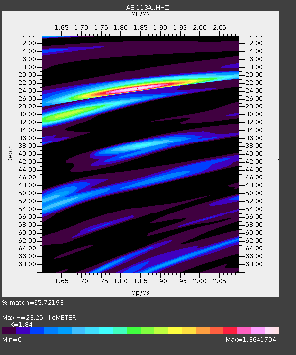
| Estimated Moho Depth: |
23.25 km |
| Estimated Crust Vp/Vs: |
1.84 |
| Assumed Crust Vp: |
6.264 km/s |
| Estimated Crust Vs: |
3.404 km/s |
| Estimated Crust Poisson's Ratio: |
0.29 |
|
| Radial Match: |
95.72193 % |
| Radial Bump: |
314 |
| Transverse Match: |
77.22208 % |
| Transverse Bump: |
400 |
| SOD ConfigId: |
13570011 |
| Insert Time: |
2019-04-29 14:54:59.662 +0000 |
| GWidth: |
2.5 |
| Max Bumps: |
400 |
| Tol: |
0.001 |
|

Signal To Noise
| Channel | StoN | STA | LTA |
| AE:113A: :HHZ:20180123T09:37:51.649991Z | 15.51364 | 1.4145592E-5 | 9.118164E-7 |
| AE:113A: :HHN:20180123T09:37:51.649991Z | 14.227918 | 7.3397773E-6 | 5.1587153E-7 |
| AE:113A: :HHE:20180123T09:37:51.649991Z | 11.103868 | 4.298449E-6 | 3.8711278E-7 |
| Arrivals |
| Ps | 3.3 SECOND |
| PpPs | 9.8 SECOND |
| PsPs/PpSs | 13 SECOND |


