You are here: Home > Network List > AE - Arizona Broadband Seismic Network Stations List
> Station PRCT Prescott > Earthquake Result Viewer
PRCT Prescott - Earthquake Result Viewer
| Earthquake location: |
Gulf Of Alaska |
| Earthquake latitude/longitude: |
56.0/-149.1 |
| Earthquake time(UTC): |
2018/01/23 (023) 09:31:42 GMT |
| Earthquake Depth: |
25 km |
| Earthquake Magnitude: |
7.9 Mww |
| Earthquake Catalog/Contributor: |
NEIC PDE/us |
|
| Network: |
AE Arizona Broadband Seismic Network |
| Station: |
PRCT Prescott |
| Lat/Lon: |
35.06 N/112.71 W |
| Elevation: |
1410 m |
|
| Distance: |
32.4 deg |
| Az: |
114.923 deg |
| Baz: |
321.666 deg |
| Ray Param: |
0.07862141 |
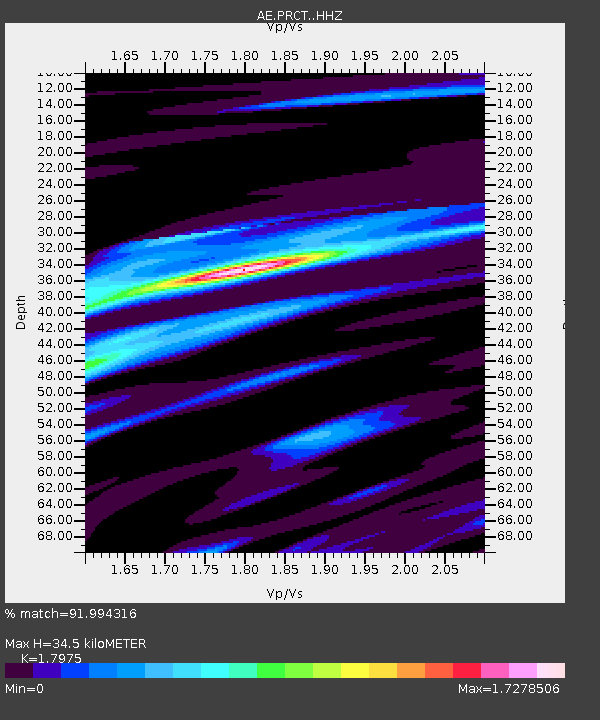
| Estimated Moho Depth: |
34.5 km |
| Estimated Crust Vp/Vs: |
1.80 |
| Assumed Crust Vp: |
6.276 km/s |
| Estimated Crust Vs: |
3.491 km/s |
| Estimated Crust Poisson's Ratio: |
0.28 |
|
| Radial Match: |
91.994316 % |
| Radial Bump: |
400 |
| Transverse Match: |
81.44259 % |
| Transverse Bump: |
400 |
| SOD ConfigId: |
13570011 |
| Insert Time: |
2019-04-29 14:55:04.394 +0000 |
| GWidth: |
2.5 |
| Max Bumps: |
400 |
| Tol: |
0.001 |
|

Signal To Noise
| Channel | StoN | STA | LTA |
| AE:PRCT: :HHZ:20180123T09:37:40.399015Z | 15.702862 | 1.1183809E-5 | 7.1221467E-7 |
| AE:PRCT: :HHN:20180123T09:37:40.399015Z | 13.118563 | 4.888569E-6 | 3.726452E-7 |
| AE:PRCT: :HHE:20180123T09:37:40.399015Z | 12.452106 | 3.816785E-6 | 3.0651725E-7 |
| Arrivals |
| Ps | 4.7 SECOND |
| PpPs | 14 SECOND |
| PsPs/PpSs | 19 SECOND |


