You are here: Home > Network List > AZ - ANZA Regional Network Stations List
> Station SND AZ.SND > Earthquake Result Viewer
SND AZ.SND - Earthquake Result Viewer
| Earthquake location: |
Gulf Of Alaska |
| Earthquake latitude/longitude: |
56.0/-149.1 |
| Earthquake time(UTC): |
2018/01/23 (023) 09:31:42 GMT |
| Earthquake Depth: |
25 km |
| Earthquake Magnitude: |
7.9 Mww |
| Earthquake Catalog/Contributor: |
NEIC PDE/us |
|
| Network: |
AZ ANZA Regional Network |
| Station: |
SND AZ.SND |
| Lat/Lon: |
33.55 N/116.61 W |
| Elevation: |
1358 m |
|
| Distance: |
31.7 deg |
| Az: |
121.492 deg |
| Baz: |
325.044 deg |
| Ray Param: |
0.07893003 |
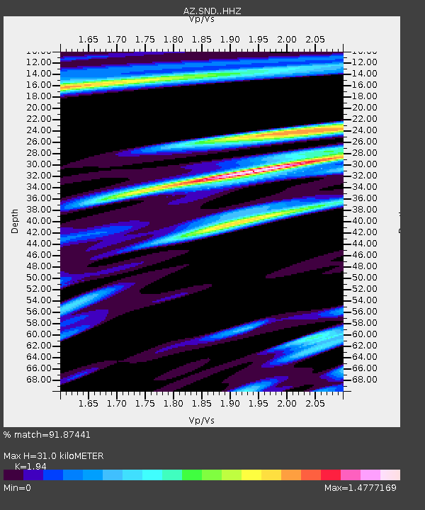
| Estimated Moho Depth: |
31.0 km |
| Estimated Crust Vp/Vs: |
1.94 |
| Assumed Crust Vp: |
6.264 km/s |
| Estimated Crust Vs: |
3.229 km/s |
| Estimated Crust Poisson's Ratio: |
0.32 |
|
| Radial Match: |
91.87441 % |
| Radial Bump: |
377 |
| Transverse Match: |
73.01493 % |
| Transverse Bump: |
400 |
| SOD ConfigId: |
13570011 |
| Insert Time: |
2019-04-29 14:55:22.457 +0000 |
| GWidth: |
2.5 |
| Max Bumps: |
400 |
| Tol: |
0.001 |
|

Signal To Noise
| Channel | StoN | STA | LTA |
| AZ:SND: :HHZ:20180123T09:37:34.048002Z | 14.954318 | 1.461848E-5 | 9.775424E-7 |
| AZ:SND: :HHN:20180123T09:37:34.048002Z | 18.674253 | 8.4468575E-6 | 4.5232636E-7 |
| AZ:SND: :HHE:20180123T09:37:34.048002Z | 5.0716515 | 5.3697263E-6 | 1.0587728E-6 |
| Arrivals |
| Ps | 5.0 SECOND |
| PpPs | 14 SECOND |
| PsPs/PpSs | 19 SECOND |


