You are here: Home > Network List > AZ - ANZA Regional Network Stations List
> Station TRO AZ.TRO > Earthquake Result Viewer
TRO AZ.TRO - Earthquake Result Viewer
| Earthquake location: |
Gulf Of Alaska |
| Earthquake latitude/longitude: |
56.0/-149.1 |
| Earthquake time(UTC): |
2018/01/23 (023) 09:31:42 GMT |
| Earthquake Depth: |
25 km |
| Earthquake Magnitude: |
7.9 Mww |
| Earthquake Catalog/Contributor: |
NEIC PDE/us |
|
| Network: |
AZ ANZA Regional Network |
| Station: |
TRO AZ.TRO |
| Lat/Lon: |
33.52 N/116.43 W |
| Elevation: |
2628 m |
|
| Distance: |
31.8 deg |
| Az: |
121.28 deg |
| Baz: |
324.967 deg |
| Ray Param: |
0.07888202 |
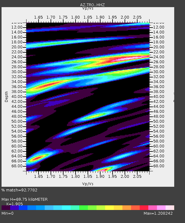
| Estimated Moho Depth: |
69.75 km |
| Estimated Crust Vp/Vs: |
1.90 |
| Assumed Crust Vp: |
6.264 km/s |
| Estimated Crust Vs: |
3.288 km/s |
| Estimated Crust Poisson's Ratio: |
0.31 |
|
| Radial Match: |
92.7782 % |
| Radial Bump: |
400 |
| Transverse Match: |
84.562515 % |
| Transverse Bump: |
400 |
| SOD ConfigId: |
13570011 |
| Insert Time: |
2019-04-29 14:55:24.269 +0000 |
| GWidth: |
2.5 |
| Max Bumps: |
400 |
| Tol: |
0.001 |
|

Signal To Noise
| Channel | StoN | STA | LTA |
| AZ:TRO: :HHZ:20180123T09:37:35.037992Z | 14.166268 | 1.3633237E-5 | 9.623732E-7 |
| AZ:TRO: :HHN:20180123T09:37:35.037992Z | 20.15586 | 9.317365E-6 | 4.622658E-7 |
| AZ:TRO: :HHE:20180123T09:37:35.037992Z | 10.9640465 | 4.580972E-6 | 4.1781763E-7 |
| Arrivals |
| Ps | 11 SECOND |
| PpPs | 30 SECOND |
| PsPs/PpSs | 41 SECOND |


