You are here: Home > Network List > CA - Catalan Seismic Network Stations List
> Station CMAS Mas de Barberans > Earthquake Result Viewer
CMAS Mas de Barberans - Earthquake Result Viewer
| Earthquake location: |
Gulf Of Alaska |
| Earthquake latitude/longitude: |
56.0/-149.1 |
| Earthquake time(UTC): |
2018/01/23 (023) 09:31:42 GMT |
| Earthquake Depth: |
25 km |
| Earthquake Magnitude: |
7.9 Mww |
| Earthquake Catalog/Contributor: |
NEIC PDE/us |
|
| Network: |
CA Catalan Seismic Network |
| Station: |
CMAS Mas de Barberans |
| Lat/Lon: |
40.73 N/0.31 E |
| Elevation: |
530 m |
|
| Distance: |
80.2 deg |
| Az: |
23.129 deg |
| Baz: |
343.142 deg |
| Ray Param: |
0.04844074 |
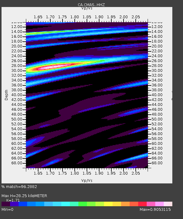
| Estimated Moho Depth: |
28.25 km |
| Estimated Crust Vp/Vs: |
1.71 |
| Assumed Crust Vp: |
6.391 km/s |
| Estimated Crust Vs: |
3.737 km/s |
| Estimated Crust Poisson's Ratio: |
0.24 |
|
| Radial Match: |
96.2882 % |
| Radial Bump: |
400 |
| Transverse Match: |
88.56677 % |
| Transverse Bump: |
400 |
| SOD ConfigId: |
13570011 |
| Insert Time: |
2019-04-29 14:55:42.241 +0000 |
| GWidth: |
2.5 |
| Max Bumps: |
400 |
| Tol: |
0.001 |
|

Signal To Noise
| Channel | StoN | STA | LTA |
| CA:CMAS: :HHZ:20180123T09:43:19.599973Z | 2.1559987 | 7.025436E-7 | 3.258553E-7 |
| CA:CMAS: :HHN:20180123T09:43:19.599973Z | 1.5020105 | 4.5793576E-7 | 3.0488187E-7 |
| CA:CMAS: :HHE:20180123T09:43:19.599973Z | 1.412017 | 3.1629682E-7 | 2.2400354E-7 |
| Arrivals |
| Ps | 3.2 SECOND |
| PpPs | 12 SECOND |
| PsPs/PpSs | 15 SECOND |


