You are here: Home > Network List > CA - Catalan Seismic Network Stations List
> Station EBR Ebre > Earthquake Result Viewer
EBR Ebre - Earthquake Result Viewer
| Earthquake location: |
Gulf Of Alaska |
| Earthquake latitude/longitude: |
56.0/-149.1 |
| Earthquake time(UTC): |
2018/01/23 (023) 09:31:42 GMT |
| Earthquake Depth: |
25 km |
| Earthquake Magnitude: |
7.9 Mww |
| Earthquake Catalog/Contributor: |
NEIC PDE/us |
|
| Network: |
CA Catalan Seismic Network |
| Station: |
EBR Ebre |
| Lat/Lon: |
40.82 N/0.49 E |
| Elevation: |
36 m |
|
| Distance: |
80.1 deg |
| Az: |
22.969 deg |
| Baz: |
343.231 deg |
| Ray Param: |
0.048475455 |
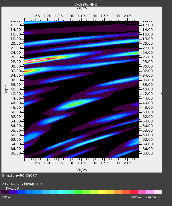
| Estimated Moho Depth: |
27.5 km |
| Estimated Crust Vp/Vs: |
1.63 |
| Assumed Crust Vp: |
6.391 km/s |
| Estimated Crust Vs: |
3.921 km/s |
| Estimated Crust Poisson's Ratio: |
0.20 |
|
| Radial Match: |
90.65087 % |
| Radial Bump: |
400 |
| Transverse Match: |
78.23995 % |
| Transverse Bump: |
400 |
| SOD ConfigId: |
13570011 |
| Insert Time: |
2019-04-29 14:55:43.538 +0000 |
| GWidth: |
2.5 |
| Max Bumps: |
400 |
| Tol: |
0.001 |
|

Signal To Noise
| Channel | StoN | STA | LTA |
| CA:EBR: :HHZ:20180123T09:43:19.320005Z | 1.6946812 | 6.269282E-7 | 3.6993876E-7 |
| CA:EBR: :HHN:20180123T09:43:19.320005Z | 1.605188 | 7.6378524E-7 | 4.758229E-7 |
| CA:EBR: :HHE:20180123T09:43:19.320005Z | 0.8043248 | 5.1087585E-7 | 6.3516114E-7 |
| Arrivals |
| Ps | 2.8 SECOND |
| PpPs | 11 SECOND |
| PsPs/PpSs | 14 SECOND |


