You are here: Home > Network List > CI - Caltech Regional Seismic Network Stations List
> Station SWS Sam W. Stewart, Westmorland, CA, USA > Earthquake Result Viewer
SWS Sam W. Stewart, Westmorland, CA, USA - Earthquake Result Viewer

| Earthquake location: |
Gulf Of Alaska |
| Earthquake latitude/longitude: |
56.0/-149.1 |
| Earthquake time(UTC): |
2018/01/23 (023) 09:31:42 GMT |
| Earthquake Depth: |
25 km |
| Earthquake Magnitude: |
7.9 Mww |
| Earthquake Catalog/Contributor: |
NEIC PDE/us |
|
| Network: |
CI Caltech Regional Seismic Network |
| Station: |
SWS Sam W. Stewart, Westmorland, CA, USA |
| Lat/Lon: |
32.94 N/115.80 W |
| Elevation: |
140 m |
|
| Distance: |
32.6 deg |
| Az: |
121.092 deg |
| Baz: |
325.152 deg |
| Ray Param: |
0.07855106 |
| Estimated Moho Depth: |
17.0 km |
| Estimated Crust Vp/Vs: |
2.02 |
| Assumed Crust Vp: |
6.155 km/s |
| Estimated Crust Vs: |
3.043 km/s |
| Estimated Crust Poisson's Ratio: |
0.34 |
|
| Radial Match: |
91.971016 % |
| Radial Bump: |
400 |
| Transverse Match: |
78.0276 % |
| Transverse Bump: |
400 |
| SOD ConfigId: |
13570011 |
| Insert Time: |
2019-04-29 14:56:20.603 +0000 |
| GWidth: |
2.5 |
| Max Bumps: |
400 |
| Tol: |
0.001 |
|
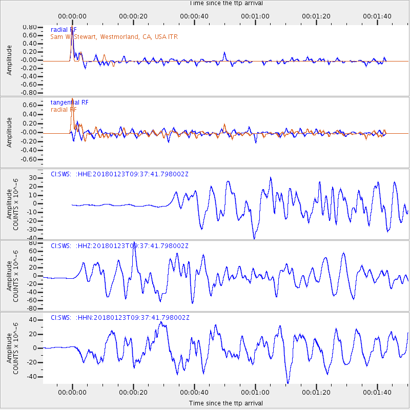
Signal To Noise
| Channel | StoN | STA | LTA |
| CI:SWS: :HHZ:20180123T09:37:41.798002Z | 14.15033 | 1.5657024E-5 | 1.1064777E-6 |
| CI:SWS: :HHN:20180123T09:37:41.798002Z | 13.424657 | 9.128338E-6 | 6.7996814E-7 |
| CI:SWS: :HHE:20180123T09:37:41.798002Z | 9.940909 | 6.9034386E-6 | 6.9444735E-7 |
| Arrivals |
| Ps | 3.0 SECOND |
| PpPs | 7.8 SECOND |
| PsPs/PpSs | 11 SECOND |


