You are here: Home > Network List > CN - Canadian National Seismograph Network Stations List
> Station DRLN Deer Lake, NFLD. > Earthquake Result Viewer
DRLN Deer Lake, NFLD. - Earthquake Result Viewer

| Earthquake location: |
Gulf Of Alaska |
| Earthquake latitude/longitude: |
56.0/-149.1 |
| Earthquake time(UTC): |
2018/01/23 (023) 09:31:42 GMT |
| Earthquake Depth: |
25 km |
| Earthquake Magnitude: |
7.9 Mww |
| Earthquake Catalog/Contributor: |
NEIC PDE/us |
|
| Network: |
CN Canadian National Seismograph Network |
| Station: |
DRLN Deer Lake, NFLD. |
| Lat/Lon: |
49.26 N/57.50 W |
| Elevation: |
238 m |
|
| Distance: |
52.0 deg |
| Az: |
56.183 deg |
| Baz: |
314.643 deg |
| Ray Param: |
0.06698385 |
| Estimated Moho Depth: |
23.75 km |
| Estimated Crust Vp/Vs: |
2.10 |
| Assumed Crust Vp: |
6.35 km/s |
| Estimated Crust Vs: |
3.027 km/s |
| Estimated Crust Poisson's Ratio: |
0.35 |
|
| Radial Match: |
98.772125 % |
| Radial Bump: |
245 |
| Transverse Match: |
88.742714 % |
| Transverse Bump: |
400 |
| SOD ConfigId: |
13570011 |
| Insert Time: |
2019-04-29 14:56:32.784 +0000 |
| GWidth: |
2.5 |
| Max Bumps: |
400 |
| Tol: |
0.001 |
|
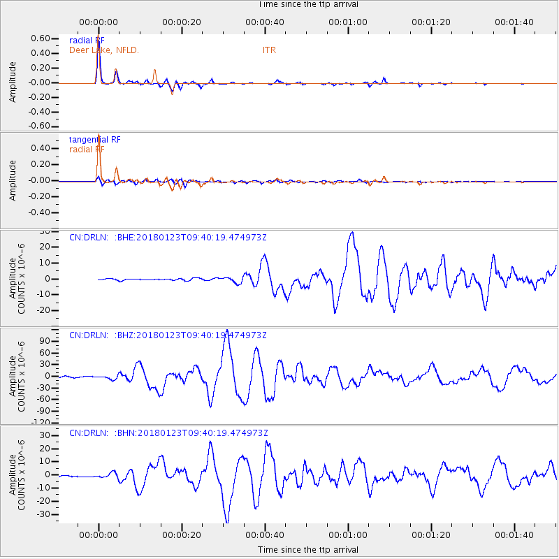
Signal To Noise
| Channel | StoN | STA | LTA |
| CN:DRLN: :BHZ:20180123T09:40:19.474973Z | 3.8444338 | 4.6043433E-6 | 1.1976648E-6 |
| CN:DRLN: :BHN:20180123T09:40:19.474973Z | 2.7889051 | 1.9731604E-6 | 7.075036E-7 |
| CN:DRLN: :BHE:20180123T09:40:19.474973Z | 3.1400912 | 1.772649E-6 | 5.645215E-7 |
| Arrivals |
| Ps | 4.3 SECOND |
| PpPs | 11 SECOND |
| PsPs/PpSs | 15 SECOND |


