You are here: Home > Network List > CN - Canadian National Seismograph Network Stations List
> Station SADO Sadowa, ON, CA > Earthquake Result Viewer
SADO Sadowa, ON, CA - Earthquake Result Viewer
| Earthquake location: |
Gulf Of Alaska |
| Earthquake latitude/longitude: |
56.0/-149.1 |
| Earthquake time(UTC): |
2018/01/23 (023) 09:31:42 GMT |
| Earthquake Depth: |
25 km |
| Earthquake Magnitude: |
7.9 Mww |
| Earthquake Catalog/Contributor: |
NEIC PDE/us |
|
| Network: |
CN Canadian National Seismograph Network |
| Station: |
SADO Sadowa, ON, CA |
| Lat/Lon: |
44.77 N/79.14 W |
| Elevation: |
228 m |
|
| Distance: |
44.1 deg |
| Az: |
74.027 deg |
| Baz: |
310.772 deg |
| Ray Param: |
0.072083555 |
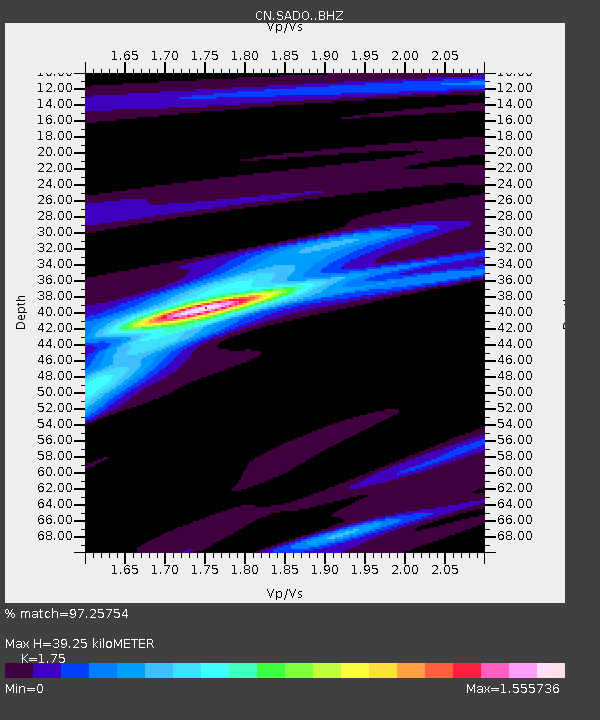
| Estimated Moho Depth: |
39.25 km |
| Estimated Crust Vp/Vs: |
1.75 |
| Assumed Crust Vp: |
6.577 km/s |
| Estimated Crust Vs: |
3.758 km/s |
| Estimated Crust Poisson's Ratio: |
0.26 |
|
| Radial Match: |
97.25754 % |
| Radial Bump: |
275 |
| Transverse Match: |
93.41132 % |
| Transverse Bump: |
400 |
| SOD ConfigId: |
13570011 |
| Insert Time: |
2019-04-29 14:56:42.785 +0000 |
| GWidth: |
2.5 |
| Max Bumps: |
400 |
| Tol: |
0.001 |
|
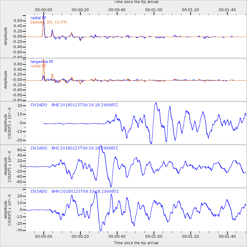
Signal To Noise
| Channel | StoN | STA | LTA |
| CN:SADO: :BHZ:20180123T09:39:18.299985Z | 10.319838 | 2.1748497E-6 | 2.1074457E-7 |
| CN:SADO: :BHN:20180123T09:39:18.299985Z | 1.7036464 | 1.0040836E-6 | 5.8937326E-7 |
| CN:SADO: :BHE:20180123T09:39:18.299985Z | 3.0901957 | 8.67741E-7 | 2.8080453E-7 |
| Arrivals |
| Ps | 4.8 SECOND |
| PpPs | 15 SECOND |
| PsPs/PpSs | 20 SECOND |


