You are here: Home > Network List > IW - Intermountain West Stations List
> Station PLID Pearl Lake, Idaho, USA > Earthquake Result Viewer
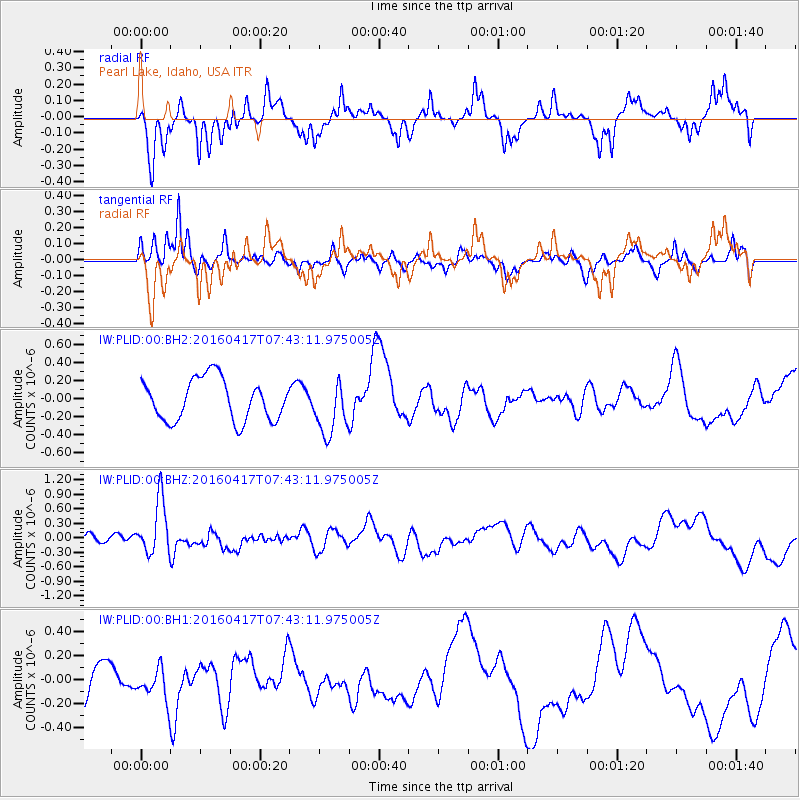
PLID Pearl Lake, Idaho, USA - Earthquake Result Viewer
*The percent match for this event was below the threshold and hence no stack was calculated.
| Earthquake location: |
Tonga Islands Region |
| Earthquake latitude/longitude: |
-23.6/-174.3 |
| Earthquake time(UTC): |
2016/04/17 (108) 07:31:03 GMT |
| Earthquake Depth: |
35 km |
| Earthquake Magnitude: |
5.8 MB |
| Earthquake Catalog/Contributor: |
NEIC PDE/NEIC COMCAT |
|
| Network: |
IW Intermountain West |
| Station: |
PLID Pearl Lake, Idaho, USA |
| Lat/Lon: |
45.09 N/116.00 W |
| Elevation: |
2164 m |
|
| Distance: |
86.5 deg |
| Az: |
37.155 deg |
| Baz: |
231.455 deg |
| Ray Param: |
$rayparam |
*The percent match for this event was below the threshold and hence was not used in the summary stack. |
|
| Radial Match: |
69.492516 % |
| Radial Bump: |
346 |
| Transverse Match: |
62.166725 % |
| Transverse Bump: |
311 |
| SOD ConfigId: |
1475611 |
| Insert Time: |
2016-05-01 07:39:36.852 +0000 |
| GWidth: |
2.5 |
| Max Bumps: |
400 |
| Tol: |
0.001 |
|
Signal To Noise
| Channel | StoN | STA | LTA |
| IW:PLID:00:BHZ:20160417T07:43:11.975005Z | 4.067255 | 5.662441E-7 | 1.3922022E-7 |
| IW:PLID:00:BH1:20160417T07:43:11.975005Z | 1.041322 | 1.347348E-7 | 1.2938823E-7 |
| IW:PLID:00:BH2:20160417T07:43:11.975005Z | 1.2849509 | 2.9406945E-7 | 2.2885658E-7 |
| Arrivals |
| Ps | |
| PpPs | |
| PsPs/PpSs | |


