You are here: Home > Network List > EI - Irish National Seismic Network (INSN) Stations List
> Station ILTH Corrakit Louth > Earthquake Result Viewer
ILTH Corrakit Louth - Earthquake Result Viewer
| Earthquake location: |
Gulf Of Alaska |
| Earthquake latitude/longitude: |
56.0/-149.1 |
| Earthquake time(UTC): |
2018/01/23 (023) 09:31:42 GMT |
| Earthquake Depth: |
25 km |
| Earthquake Magnitude: |
7.9 Mww |
| Earthquake Catalog/Contributor: |
NEIC PDE/us |
|
| Network: |
EI Irish National Seismic Network (INSN) |
| Station: |
ILTH Corrakit Louth |
| Lat/Lon: |
54.06 N/6.27 W |
| Elevation: |
227 m |
|
| Distance: |
66.1 deg |
| Az: |
22.943 deg |
| Baz: |
338.224 deg |
| Ray Param: |
0.057800226 |
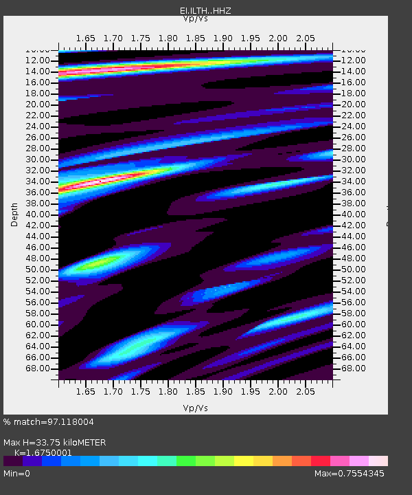
| Estimated Moho Depth: |
33.75 km |
| Estimated Crust Vp/Vs: |
1.68 |
| Assumed Crust Vp: |
6.276 km/s |
| Estimated Crust Vs: |
3.747 km/s |
| Estimated Crust Poisson's Ratio: |
0.22 |
|
| Radial Match: |
97.118004 % |
| Radial Bump: |
328 |
| Transverse Match: |
79.76111 % |
| Transverse Bump: |
400 |
| SOD ConfigId: |
13570011 |
| Insert Time: |
2019-04-29 14:57:12.042 +0000 |
| GWidth: |
2.5 |
| Max Bumps: |
400 |
| Tol: |
0.001 |
|

Signal To Noise
| Channel | StoN | STA | LTA |
| EI:ILTH: :HHZ:20180123T09:41:56.820005Z | 1.308634 | 1.9927625E-6 | 1.5227805E-6 |
| EI:ILTH: :HHN:20180123T09:41:56.820005Z | 1.4304821 | 1.2516745E-6 | 8.7500183E-7 |
| EI:ILTH: :HHE:20180123T09:41:56.820005Z | 0.9099391 | 9.017566E-7 | 9.910076E-7 |
| Arrivals |
| Ps | 3.8 SECOND |
| PpPs | 14 SECOND |
| PsPs/PpSs | 18 SECOND |


