You are here: Home > Network List > EI - Irish National Seismic Network (INSN) Stations List
> Station IWEX CARRICKBYRNE, CO WEXFORD > Earthquake Result Viewer
IWEX CARRICKBYRNE, CO WEXFORD - Earthquake Result Viewer
| Earthquake location: |
Gulf Of Alaska |
| Earthquake latitude/longitude: |
56.0/-149.1 |
| Earthquake time(UTC): |
2018/01/23 (023) 09:31:42 GMT |
| Earthquake Depth: |
25 km |
| Earthquake Magnitude: |
7.9 Mww |
| Earthquake Catalog/Contributor: |
NEIC PDE/us |
|
| Network: |
EI Irish National Seismic Network (INSN) |
| Station: |
IWEX CARRICKBYRNE, CO WEXFORD |
| Lat/Lon: |
52.37 N/6.77 W |
| Elevation: |
180 m |
|
| Distance: |
67.6 deg |
| Az: |
23.932 deg |
| Baz: |
338.206 deg |
| Ray Param: |
0.056846775 |
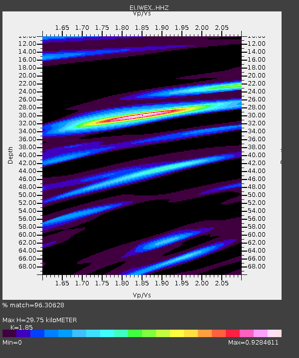
| Estimated Moho Depth: |
29.75 km |
| Estimated Crust Vp/Vs: |
1.85 |
| Assumed Crust Vp: |
6.276 km/s |
| Estimated Crust Vs: |
3.392 km/s |
| Estimated Crust Poisson's Ratio: |
0.29 |
|
| Radial Match: |
96.30628 % |
| Radial Bump: |
274 |
| Transverse Match: |
86.24669 % |
| Transverse Bump: |
400 |
| SOD ConfigId: |
13570011 |
| Insert Time: |
2019-04-29 14:57:13.808 +0000 |
| GWidth: |
2.5 |
| Max Bumps: |
400 |
| Tol: |
0.001 |
|

Signal To Noise
| Channel | StoN | STA | LTA |
| EI:IWEX: :HHZ:20180123T09:42:06.039976Z | 2.8446622 | 1.9104248E-6 | 6.7158226E-7 |
| EI:IWEX: :HHN:20180123T09:42:06.039976Z | 2.0294771 | 1.3675453E-6 | 6.7384127E-7 |
| EI:IWEX: :HHE:20180123T09:42:06.039976Z | 1.7385522 | 1.1319834E-6 | 6.511069E-7 |
| Arrivals |
| Ps | 4.2 SECOND |
| PpPs | 13 SECOND |
| PsPs/PpSs | 17 SECOND |


