You are here: Home > Network List > GB - Great Britain Seismograph Network Stations List
> Station CLGH CUSHENDALL, NORTHERN IRELAND > Earthquake Result Viewer
CLGH CUSHENDALL, NORTHERN IRELAND - Earthquake Result Viewer
| Earthquake location: |
Gulf Of Alaska |
| Earthquake latitude/longitude: |
56.0/-149.1 |
| Earthquake time(UTC): |
2018/01/23 (023) 09:31:42 GMT |
| Earthquake Depth: |
25 km |
| Earthquake Magnitude: |
7.9 Mww |
| Earthquake Catalog/Contributor: |
NEIC PDE/us |
|
| Network: |
GB Great Britain Seismograph Network |
| Station: |
CLGH CUSHENDALL, NORTHERN IRELAND |
| Lat/Lon: |
55.08 N/6.11 W |
| Elevation: |
239 m |
|
| Distance: |
65.2 deg |
| Az: |
22.431 deg |
| Baz: |
338.139 deg |
| Ray Param: |
0.05840519 |
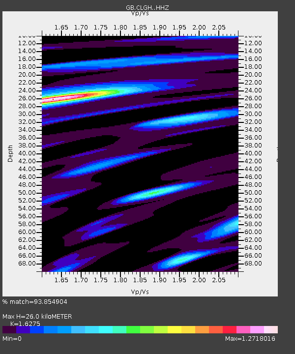
| Estimated Moho Depth: |
26.0 km |
| Estimated Crust Vp/Vs: |
1.63 |
| Assumed Crust Vp: |
6.276 km/s |
| Estimated Crust Vs: |
3.856 km/s |
| Estimated Crust Poisson's Ratio: |
0.20 |
|
| Radial Match: |
93.854904 % |
| Radial Bump: |
288 |
| Transverse Match: |
77.56577 % |
| Transverse Bump: |
400 |
| SOD ConfigId: |
13570011 |
| Insert Time: |
2019-04-29 14:57:22.468 +0000 |
| GWidth: |
2.5 |
| Max Bumps: |
400 |
| Tol: |
0.001 |
|

Signal To Noise
| Channel | StoN | STA | LTA |
| GB:CLGH: :HHZ:20180123T09:41:50.890012Z | 1.8502498 | 2.5051909E-6 | 1.3539744E-6 |
| GB:CLGH: :HHN:20180123T09:41:50.890012Z | 0.78919876 | 7.8385546E-7 | 9.932295E-7 |
| GB:CLGH: :HHE:20180123T09:41:50.890012Z | 2.1119692 | 1.2437191E-6 | 5.888907E-7 |
| Arrivals |
| Ps | 2.7 SECOND |
| PpPs | 10 SECOND |
| PsPs/PpSs | 13 SECOND |


