You are here: Home > Network List > TA - USArray Transportable Network (new EarthScope stations) Stations List
> Station T23A Casias Ranch, Antonito, CO, USA > Earthquake Result Viewer
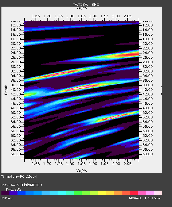
T23A Casias Ranch, Antonito, CO, USA - Earthquake Result Viewer
| Earthquake location: |
Kermadec Islands, New Zealand |
| Earthquake latitude/longitude: |
-29.8/-177.7 |
| Earthquake time(UTC): |
2008/09/29 (273) 15:19:31 GMT |
| Earthquake Depth: |
36 km |
| Earthquake Magnitude: |
6.5 MB, 6.7 MS, 7.0 MW, 7.0 MW |
| Earthquake Catalog/Contributor: |
WHDF/NEIC |
|
| Network: |
TA USArray Transportable Network (new EarthScope stations) |
| Station: |
T23A Casias Ranch, Antonito, CO, USA |
| Lat/Lon: |
37.04 N/106.04 W |
| Elevation: |
2429 m |
|
| Distance: |
94.4 deg |
| Az: |
49.619 deg |
| Baz: |
235.873 deg |
| Ray Param: |
0.041033342 |
| Estimated Moho Depth: |
39.0 km |
| Estimated Crust Vp/Vs: |
1.84 |
| Assumed Crust Vp: |
6.159 km/s |
| Estimated Crust Vs: |
3.356 km/s |
| Estimated Crust Poisson's Ratio: |
0.29 |
|
| Radial Match: |
90.22654 % |
| Radial Bump: |
400 |
| Transverse Match: |
86.78073 % |
| Transverse Bump: |
400 |
| SOD ConfigId: |
2560 |
| Insert Time: |
2010-03-06 08:12:02.959 +0000 |
| GWidth: |
2.5 |
| Max Bumps: |
400 |
| Tol: |
0.001 |
|

Signal To Noise
| Channel | StoN | STA | LTA |
| TA:T23A: :BHZ:20080929T15:32:16.425022Z | 3.1851828 | 2.8684212E-7 | 9.005515E-8 |
| TA:T23A: :BHN:20080929T15:32:16.425022Z | 0.8856914 | 1.4992195E-7 | 1.6927109E-7 |
| TA:T23A: :BHE:20080929T15:32:16.425022Z | 0.9725085 | 1.0407406E-7 | 1.0701609E-7 |
| Arrivals |
| Ps | 5.4 SECOND |
| PpPs | 18 SECOND |
| PsPs/PpSs | 23 SECOND |


