You are here: Home > Network List > IN - National Seismic Network of India Stations List
> Station PBA Port Blair, Andaman and Nicobar Islands, India > Earthquake Result Viewer
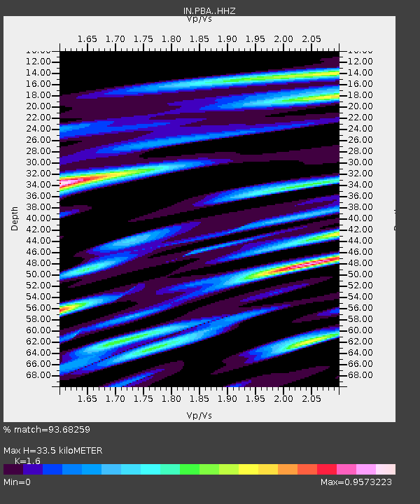
PBA Port Blair, Andaman and Nicobar Islands, India - Earthquake Result Viewer
| Earthquake location: |
Gulf Of Alaska |
| Earthquake latitude/longitude: |
56.0/-149.1 |
| Earthquake time(UTC): |
2018/01/23 (023) 09:31:42 GMT |
| Earthquake Depth: |
25 km |
| Earthquake Magnitude: |
7.9 Mww |
| Earthquake Catalog/Contributor: |
NEIC PDE/us |
|
| Network: |
IN National Seismic Network of India |
| Station: |
PBA Port Blair, Andaman and Nicobar Islands, India |
| Lat/Lon: |
11.66 N/92.74 E |
| Elevation: |
79 m |
|
| Distance: |
95.4 deg |
| Az: |
299.854 deg |
| Baz: |
29.785 deg |
| Ray Param: |
0.04079325 |
| Estimated Moho Depth: |
33.5 km |
| Estimated Crust Vp/Vs: |
1.60 |
| Assumed Crust Vp: |
6.32 km/s |
| Estimated Crust Vs: |
3.95 km/s |
| Estimated Crust Poisson's Ratio: |
0.18 |
|
| Radial Match: |
93.68259 % |
| Radial Bump: |
400 |
| Transverse Match: |
92.20096 % |
| Transverse Bump: |
400 |
| SOD ConfigId: |
13570011 |
| Insert Time: |
2019-04-29 14:58:17.530 +0000 |
| GWidth: |
2.5 |
| Max Bumps: |
400 |
| Tol: |
0.001 |
|

Signal To Noise
| Channel | StoN | STA | LTA |
| IN:PBA: :HHZ:20180123T09:44:33.340024Z | 5.5757947 | 2.9047244E-6 | 5.2095254E-7 |
| IN:PBA: :HHN:20180123T09:44:33.340024Z | 2.5986946 | 1.0385064E-6 | 3.9962617E-7 |
| IN:PBA: :HHE:20180123T09:44:33.340024Z | 1.5417295 | 6.614933E-7 | 4.2905924E-7 |
| Arrivals |
| Ps | 3.2 SECOND |
| PpPs | 13 SECOND |
| PsPs/PpSs | 17 SECOND |


