You are here: Home > Network List > IU - Global Seismograph Network (GSN - IRIS/USGS) Stations List
> Station GRFO Grafenberg, Germany > Earthquake Result Viewer
GRFO Grafenberg, Germany - Earthquake Result Viewer

| Earthquake location: |
Gulf Of Alaska |
| Earthquake latitude/longitude: |
56.0/-149.1 |
| Earthquake time(UTC): |
2018/01/23 (023) 09:31:42 GMT |
| Earthquake Depth: |
25 km |
| Earthquake Magnitude: |
7.9 Mww |
| Earthquake Catalog/Contributor: |
NEIC PDE/us |
|
| Network: |
IU Global Seismograph Network (GSN - IRIS/USGS) |
| Station: |
GRFO Grafenberg, Germany |
| Lat/Lon: |
49.69 N/11.22 E |
| Elevation: |
384 m |
|
| Distance: |
73.4 deg |
| Az: |
13.213 deg |
| Baz: |
348.61 deg |
| Ray Param: |
0.05302607 |
| Estimated Moho Depth: |
26.75 km |
| Estimated Crust Vp/Vs: |
2.10 |
| Assumed Crust Vp: |
6.182 km/s |
| Estimated Crust Vs: |
2.947 km/s |
| Estimated Crust Poisson's Ratio: |
0.35 |
|
| Radial Match: |
96.50951 % |
| Radial Bump: |
400 |
| Transverse Match: |
89.795296 % |
| Transverse Bump: |
400 |
| SOD ConfigId: |
13570011 |
| Insert Time: |
2019-04-29 14:58:20.075 +0000 |
| GWidth: |
2.5 |
| Max Bumps: |
400 |
| Tol: |
0.001 |
|
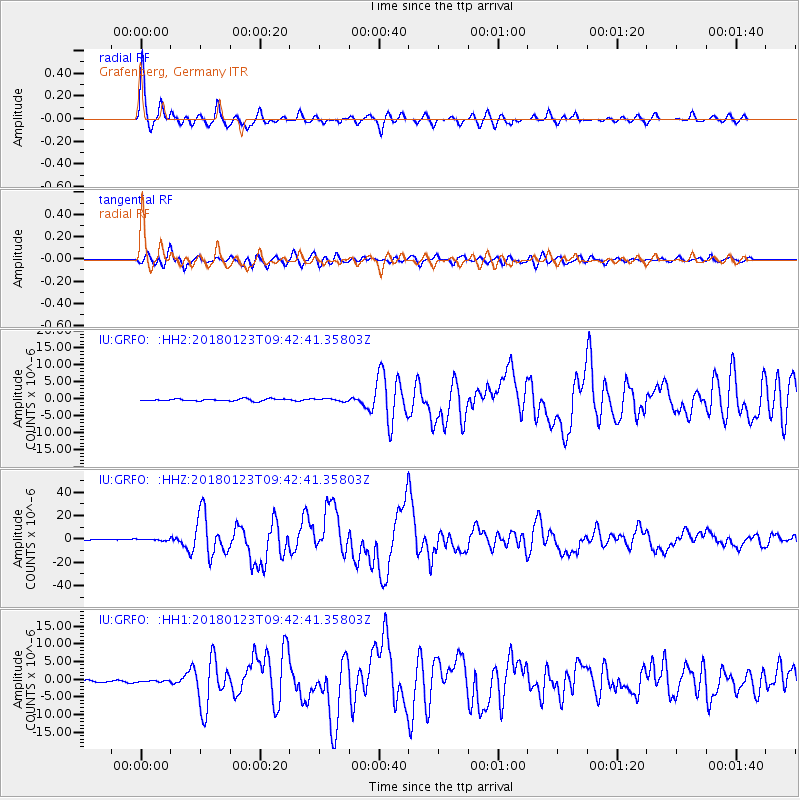
Signal To Noise
| Channel | StoN | STA | LTA |
| IU:GRFO: :HHZ:20180123T09:42:41.35803Z | 2.4019 | 5.8458033E-7 | 2.4338246E-7 |
| IU:GRFO: :HH1:20180123T09:42:41.35803Z | 1.0429738 | 2.1964155E-7 | 2.1059165E-7 |
| IU:GRFO: :HH2:20180123T09:42:41.35803Z | 1.2778106 | 3.7655926E-7 | 2.9469098E-7 |
| Arrivals |
| Ps | 4.9 SECOND |
| PpPs | 13 SECOND |
| PsPs/PpSs | 18 SECOND |


