You are here: Home > Network List > IU - Global Seismograph Network (GSN - IRIS/USGS) Stations List
> Station MACI Morro de la Arena, Canary Islands > Earthquake Result Viewer
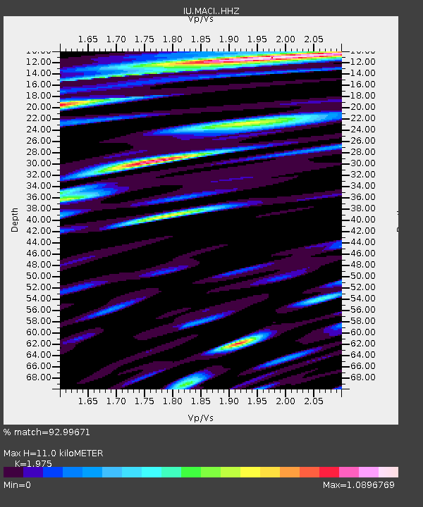
MACI Morro de la Arena, Canary Islands - Earthquake Result Viewer
| Earthquake location: |
Gulf Of Alaska |
| Earthquake latitude/longitude: |
56.0/-149.1 |
| Earthquake time(UTC): |
2018/01/23 (023) 09:31:42 GMT |
| Earthquake Depth: |
25 km |
| Earthquake Magnitude: |
7.9 Mww |
| Earthquake Catalog/Contributor: |
NEIC PDE/us |
|
| Network: |
IU Global Seismograph Network (GSN - IRIS/USGS) |
| Station: |
MACI Morro de la Arena, Canary Islands |
| Lat/Lon: |
28.25 N/16.51 W |
| Elevation: |
1674 m |
|
| Distance: |
86.9 deg |
| Az: |
40.598 deg |
| Baz: |
335.551 deg |
| Ray Param: |
0.043722585 |
| Estimated Moho Depth: |
11.0 km |
| Estimated Crust Vp/Vs: |
1.98 |
| Assumed Crust Vp: |
4.662 km/s |
| Estimated Crust Vs: |
2.361 km/s |
| Estimated Crust Poisson's Ratio: |
0.33 |
|
| Radial Match: |
92.99671 % |
| Radial Bump: |
400 |
| Transverse Match: |
92.1269 % |
| Transverse Bump: |
400 |
| SOD ConfigId: |
13570011 |
| Insert Time: |
2019-04-29 14:58:21.704 +0000 |
| GWidth: |
2.5 |
| Max Bumps: |
400 |
| Tol: |
0.001 |
|

Signal To Noise
| Channel | StoN | STA | LTA |
| IU:MACI: :HHZ:20180123T09:43:53.840024Z | 2.2110348 | 1.2610004E-6 | 5.703214E-7 |
| IU:MACI: :HHN:20180123T09:43:53.840024Z | 0.95485544 | 6.548376E-7 | 6.857976E-7 |
| IU:MACI: :HHE:20180123T09:43:53.840024Z | 1.0069925 | 5.464815E-7 | 5.4268673E-7 |
| Arrivals |
| Ps | 2.3 SECOND |
| PpPs | 6.9 SECOND |
| PsPs/PpSs | 9.3 SECOND |


