You are here: Home > Network List > JP - Japan Meteorological Agency Seismic Network Stations List
> Station JTM Aomori Tenma > Earthquake Result Viewer
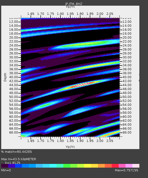
JTM Aomori Tenma - Earthquake Result Viewer
| Earthquake location: |
Gulf Of Alaska |
| Earthquake latitude/longitude: |
56.0/-149.1 |
| Earthquake time(UTC): |
2018/01/23 (023) 09:31:42 GMT |
| Earthquake Depth: |
25 km |
| Earthquake Magnitude: |
7.9 Mww |
| Earthquake Catalog/Contributor: |
NEIC PDE/us |
|
| Network: |
JP Japan Meteorological Agency Seismic Network |
| Station: |
JTM Aomori Tenma |
| Lat/Lon: |
40.79 N/141.06 E |
| Elevation: |
130 m |
|
| Distance: |
46.7 deg |
| Az: |
281.788 deg |
| Baz: |
46.337 deg |
| Ray Param: |
0.07041389 |
| Estimated Moho Depth: |
43.5 km |
| Estimated Crust Vp/Vs: |
1.91 |
| Assumed Crust Vp: |
6.468 km/s |
| Estimated Crust Vs: |
3.382 km/s |
| Estimated Crust Poisson's Ratio: |
0.31 |
|
| Radial Match: |
90.44285 % |
| Radial Bump: |
400 |
| Transverse Match: |
78.48087 % |
| Transverse Bump: |
400 |
| SOD ConfigId: |
13570011 |
| Insert Time: |
2019-04-29 14:58:32.969 +0000 |
| GWidth: |
2.5 |
| Max Bumps: |
400 |
| Tol: |
0.001 |
|

Signal To Noise
| Channel | StoN | STA | LTA |
| JP:JTM: :BHZ:20180123T09:39:39.149991Z | 6.7738943 | 9.674624E-6 | 1.4282219E-6 |
| JP:JTM: :BHN:20180123T09:39:39.149991Z | 1.8370872 | 3.2638764E-6 | 1.7766585E-6 |
| JP:JTM: :BHE:20180123T09:39:39.149991Z | 3.6092 | 2.88551E-6 | 7.9948745E-7 |
| Arrivals |
| Ps | 6.5 SECOND |
| PpPs | 18 SECOND |
| PsPs/PpSs | 25 SECOND |


