You are here: Home > Network List > KO - Kandilli Observatory Digital Broadband Seismic Network Stations List
> Station MDUB Mudurnu-Bolu-Turkey > Earthquake Result Viewer
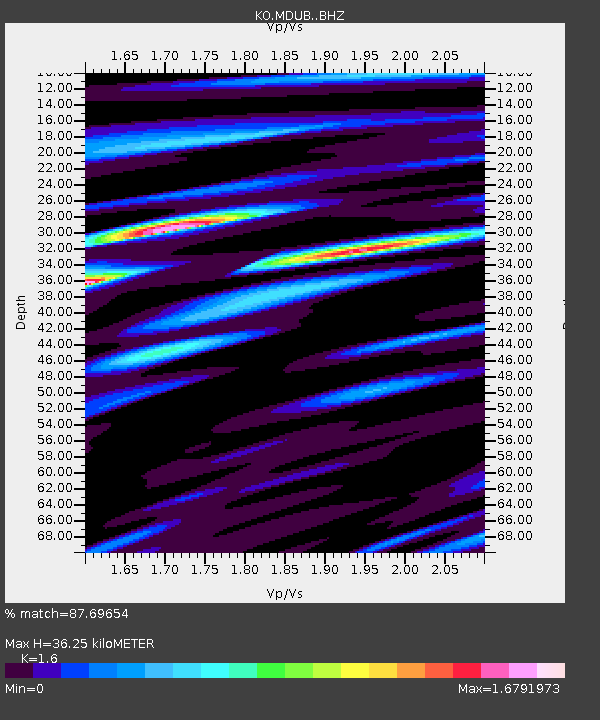
MDUB Mudurnu-Bolu-Turkey - Earthquake Result Viewer
| Earthquake location: |
Gulf Of Alaska |
| Earthquake latitude/longitude: |
56.0/-149.1 |
| Earthquake time(UTC): |
2018/01/23 (023) 09:31:42 GMT |
| Earthquake Depth: |
25 km |
| Earthquake Magnitude: |
7.9 Mww |
| Earthquake Catalog/Contributor: |
NEIC PDE/us |
|
| Network: |
KO Kandilli Observatory Digital Broadband Seismic Network |
| Station: |
MDUB Mudurnu-Bolu-Turkey |
| Lat/Lon: |
40.47 N/31.20 E |
| Elevation: |
1109 m |
|
| Distance: |
83.9 deg |
| Az: |
359.792 deg |
| Baz: |
0.153 deg |
| Ray Param: |
0.045866404 |
| Estimated Moho Depth: |
36.25 km |
| Estimated Crust Vp/Vs: |
1.60 |
| Assumed Crust Vp: |
6.287 km/s |
| Estimated Crust Vs: |
3.93 km/s |
| Estimated Crust Poisson's Ratio: |
0.18 |
|
| Radial Match: |
87.69654 % |
| Radial Bump: |
400 |
| Transverse Match: |
92.49829 % |
| Transverse Bump: |
400 |
| SOD ConfigId: |
13570011 |
| Insert Time: |
2019-04-29 14:58:41.064 +0000 |
| GWidth: |
2.5 |
| Max Bumps: |
400 |
| Tol: |
0.001 |
|

Signal To Noise
| Channel | StoN | STA | LTA |
| KO:MDUB: :BHZ:20180123T09:43:38.91998Z | 4.4107523 | 3.1255427E-6 | 7.086189E-7 |
| KO:MDUB: :BHN:20180123T09:43:38.91998Z | 1.4214077 | 1.846604E-6 | 1.2991375E-6 |
| KO:MDUB: :BHE:20180123T09:43:38.91998Z | 0.7354613 | 1.0545722E-6 | 1.4338921E-6 |
| Arrivals |
| Ps | 3.6 SECOND |
| PpPs | 15 SECOND |
| PsPs/PpSs | 18 SECOND |


