You are here: Home > Network List > TA - USArray Transportable Network (new EarthScope stations) Stations List
> Station T23A Casias Ranch, Antonito, CO, USA > Earthquake Result Viewer
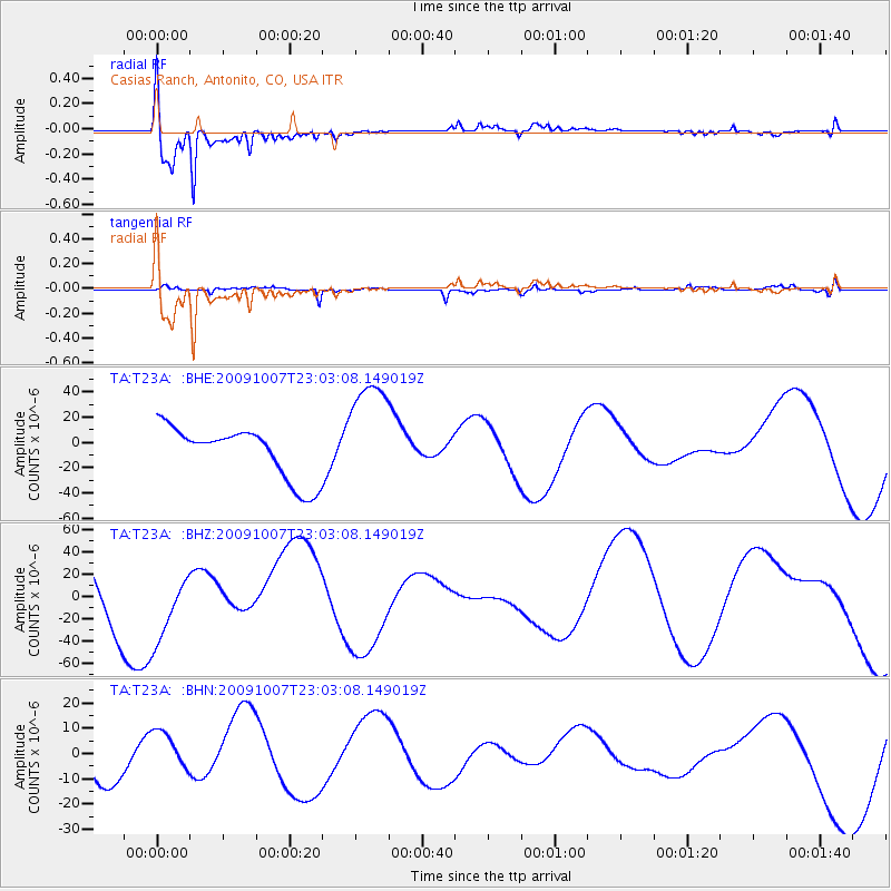
T23A Casias Ranch, Antonito, CO, USA - Earthquake Result Viewer

| Earthquake location: |
Santa Cruz Islands |
| Earthquake latitude/longitude: |
-12.4/166.1 |
| Earthquake time(UTC): |
2009/10/07 (280) 22:50:15 GMT |
| Earthquake Depth: |
21 km |
| Earthquake Magnitude: |
5.8 MB |
| Earthquake Catalog/Contributor: |
WHDF/NEIC |
|
| Network: |
TA USArray Transportable Network (new EarthScope stations) |
| Station: |
T23A Casias Ranch, Antonito, CO, USA |
| Lat/Lon: |
37.04 N/106.04 W |
| Elevation: |
2429 m |
|
| Distance: |
95.7 deg |
| Az: |
53.474 deg |
| Baz: |
258.857 deg |
| Ray Param: |
0.04071274 |
| Estimated Moho Depth: |
11.0 km |
| Estimated Crust Vp/Vs: |
1.61 |
| Assumed Crust Vp: |
6.159 km/s |
| Estimated Crust Vs: |
3.831 km/s |
| Estimated Crust Poisson's Ratio: |
0.18 |
|
| Radial Match: |
94.798355 % |
| Radial Bump: |
352 |
| Transverse Match: |
61.36448 % |
| Transverse Bump: |
294 |
| SOD ConfigId: |
2622 |
| Insert Time: |
2010-03-06 08:12:34.965 +0000 |
| GWidth: |
2.5 |
| Max Bumps: |
400 |
| Tol: |
0.001 |
|
Signal To Noise
| Channel | StoN | STA | LTA |
| TA:T23A: :BHZ:20091007T23:03:08.149019Z | 1.7225689 | 3.465254E-5 | 2.0116782E-5 |
| TA:T23A: :BHN:20091007T23:03:08.149019Z | 1.496816 | 8.760235E-6 | 5.8525798E-6 |
| TA:T23A: :BHE:20091007T23:03:08.149019Z | 2.2173648 | 4.532731E-5 | 2.0441972E-5 |
| Arrivals |
| Ps | 1.1 SECOND |
| PpPs | 4.6 SECOND |
| PsPs/PpSs | 5.7 SECOND |


