You are here: Home > Network List > TA - USArray Transportable Network (new EarthScope stations) Stations List
> Station T23A Casias Ranch, Antonito, CO, USA > Earthquake Result Viewer
T23A Casias Ranch, Antonito, CO, USA - Earthquake Result Viewer
| Earthquake location: |
Vanuatu Islands |
| Earthquake latitude/longitude: |
-13.1/166.5 |
| Earthquake time(UTC): |
2009/10/07 (280) 23:13:48 GMT |
| Earthquake Depth: |
31 km |
| Earthquake Magnitude: |
6.4 MB, 7.2 MS, 7.4 MW, 7.4 MW |
| Earthquake Catalog/Contributor: |
WHDF/NEIC |
|
| Network: |
TA USArray Transportable Network (new EarthScope stations) |
| Station: |
T23A Casias Ranch, Antonito, CO, USA |
| Lat/Lon: |
37.04 N/106.04 W |
| Elevation: |
2429 m |
|
| Distance: |
95.8 deg |
| Az: |
53.464 deg |
| Baz: |
258.053 deg |
| Ray Param: |
0.040681187 |
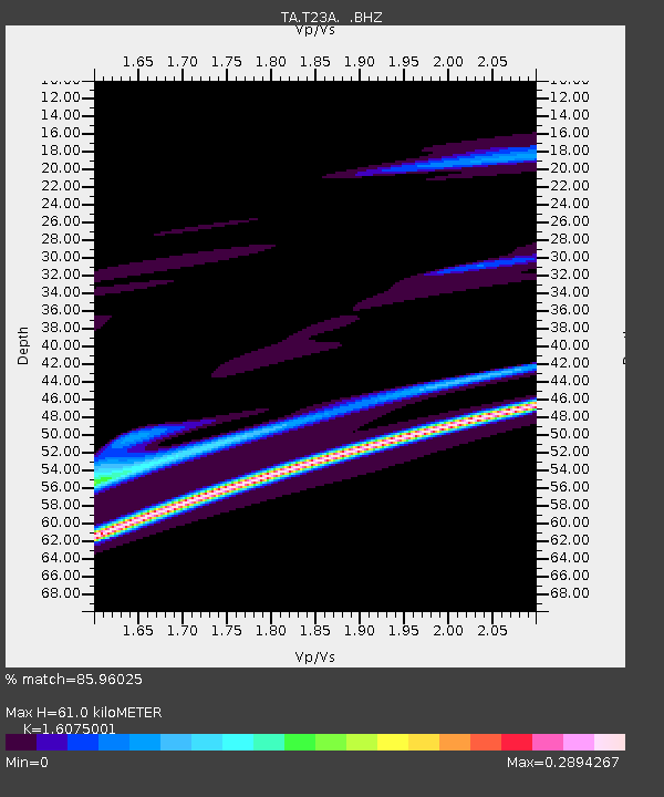
| Estimated Moho Depth: |
61.0 km |
| Estimated Crust Vp/Vs: |
1.61 |
| Assumed Crust Vp: |
6.159 km/s |
| Estimated Crust Vs: |
3.831 km/s |
| Estimated Crust Poisson's Ratio: |
0.18 |
|
| Radial Match: |
85.96025 % |
| Radial Bump: |
400 |
| Transverse Match: |
84.67256 % |
| Transverse Bump: |
301 |
| SOD ConfigId: |
2622 |
| Insert Time: |
2010-03-06 08:12:36.545 +0000 |
| GWidth: |
2.5 |
| Max Bumps: |
400 |
| Tol: |
0.001 |
|

Signal To Noise
| Channel | StoN | STA | LTA |
| TA:T23A: :BHZ:20091007T23:26:39.699001Z | 3.1134982 | 4.0182604E-5 | 1.2905934E-5 |
| TA:T23A: :BHN:20091007T23:26:39.699001Z | 0.78117025 | 8.6912405E-6 | 1.1125924E-5 |
| TA:T23A: :BHE:20091007T23:26:39.699001Z | 1.6755943 | 1.2808576E-5 | 7.644198E-6 |
| Arrivals |
| Ps | 6.1 SECOND |
| PpPs | 25 SECOND |
| PsPs/PpSs | 31 SECOND |


