You are here: Home > Network List > TA - USArray Transportable Network (new EarthScope stations) Stations List
> Station T23A Casias Ranch, Antonito, CO, USA > Earthquake Result Viewer
T23A Casias Ranch, Antonito, CO, USA - Earthquake Result Viewer

| Earthquake location: |
Azores Islands Region |
| Earthquake latitude/longitude: |
36.2/-33.9 |
| Earthquake time(UTC): |
2009/11/04 (308) 18:41:44 GMT |
| Earthquake Depth: |
10 km |
| Earthquake Magnitude: |
5.7 MB, 5.6 MS, 5.9 MW, 5.8 MW |
| Earthquake Catalog/Contributor: |
WHDF/NEIC |
|
| Network: |
TA USArray Transportable Network (new EarthScope stations) |
| Station: |
T23A Casias Ranch, Antonito, CO, USA |
| Lat/Lon: |
37.04 N/106.04 W |
| Elevation: |
2429 m |
|
| Distance: |
56.6 deg |
| Az: |
294.142 deg |
| Baz: |
67.359 deg |
| Ray Param: |
0.06404342 |
| Estimated Moho Depth: |
19.5 km |
| Estimated Crust Vp/Vs: |
2.06 |
| Assumed Crust Vp: |
6.159 km/s |
| Estimated Crust Vs: |
2.997 km/s |
| Estimated Crust Poisson's Ratio: |
0.34 |
|
| Radial Match: |
85.41241 % |
| Radial Bump: |
373 |
| Transverse Match: |
67.526726 % |
| Transverse Bump: |
323 |
| SOD ConfigId: |
2622 |
| Insert Time: |
2010-03-06 08:12:41.295 +0000 |
| GWidth: |
2.5 |
| Max Bumps: |
400 |
| Tol: |
0.001 |
|
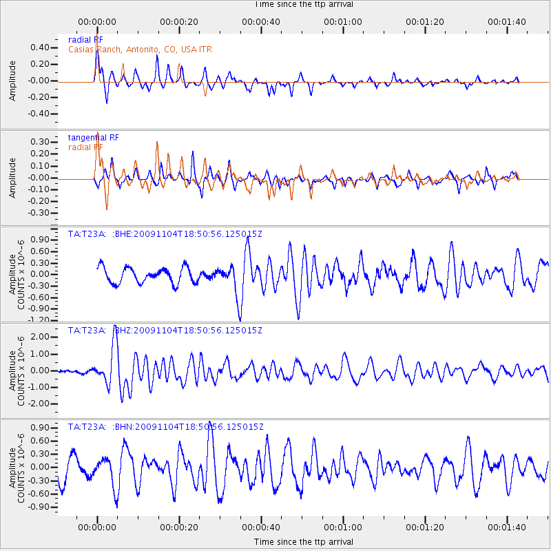
Signal To Noise
| Channel | StoN | STA | LTA |
| TA:T23A: :BHZ:20091104T18:50:56.125015Z | 15.323581 | 1.222706E-6 | 7.979245E-8 |
| TA:T23A: :BHN:20091104T18:50:56.125015Z | 1.6518501 | 3.2368303E-7 | 1.9595181E-7 |
| TA:T23A: :BHE:20091104T18:50:56.125015Z | 1.9925445 | 3.9751214E-7 | 1.9949977E-7 |
| Arrivals |
| Ps | 3.5 SECOND |
| PpPs | 9.3 SECOND |
| PsPs/PpSs | 13 SECOND |


